You are here: Home > Network List > IU - Global Seismograph Network (GSN - IRIS/USGS) Stations List
> Station SLBS Sierra la Laguna Baja California Sur, Mexico > Earthquake Result Viewer
SLBS Sierra la Laguna Baja California Sur, Mexico - Earthquake Result Viewer

| Earthquake location: |
Easter Island Region |
| Earthquake latitude/longitude: |
-22.6/-114.2 |
| Earthquake time(UTC): |
2022/07/12 (193) 19:17:00 GMT |
| Earthquake Depth: |
10 km |
| Earthquake Magnitude: |
6.4 mb |
| Earthquake Catalog/Contributor: |
NEIC PDE/us |
|
| Network: |
IU Global Seismograph Network (GSN - IRIS/USGS) |
| Station: |
SLBS Sierra la Laguna Baja California Sur, Mexico |
| Lat/Lon: |
23.69 N/109.94 W |
| Elevation: |
825 m |
|
| Distance: |
46.2 deg |
| Az: |
5.403 deg |
| Baz: |
185.446 deg |
| Ray Param: |
0.070812054 |
| Estimated Moho Depth: |
23.5 km |
| Estimated Crust Vp/Vs: |
2.10 |
| Assumed Crust Vp: |
6.183 km/s |
| Estimated Crust Vs: |
2.948 km/s |
| Estimated Crust Poisson's Ratio: |
0.35 |
|
| Radial Match: |
80.18115 % |
| Radial Bump: |
321 |
| Transverse Match: |
77.109726 % |
| Transverse Bump: |
318 |
| SOD ConfigId: |
28208852 |
| Insert Time: |
2022-07-26 19:42:11.131 +0000 |
| GWidth: |
2.5 |
| Max Bumps: |
400 |
| Tol: |
0.001 |
|
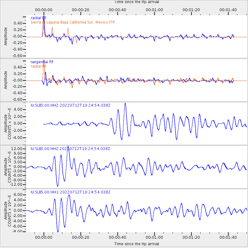
Signal To Noise
| Channel | StoN | STA | LTA |
| IU:SLBS:00:HHZ:20220712T19:24:54.038Z | 3.1243954 | 1.0536983E-6 | 3.372487E-7 |
| IU:SLBS:00:HH1:20220712T19:24:54.038Z | 3.1195107 | 7.383798E-7 | 2.3669732E-7 |
| IU:SLBS:00:HH2:20220712T19:24:54.038Z | 0.82208353 | 2.1321193E-7 | 2.5935555E-7 |
| Arrivals |
| Ps | 4.4 SECOND |
| PpPs | 11 SECOND |
| PsPs/PpSs | 16 SECOND |


