You are here: Home > Network List > LD - Lamont-Doherty Cooperative Seismographic Network Stations List
> Station GEDE Greenville, DE, USA > Earthquake Result Viewer
GEDE Greenville, DE, USA - Earthquake Result Viewer
| Earthquake location: |
Easter Island Region |
| Earthquake latitude/longitude: |
-22.6/-114.2 |
| Earthquake time(UTC): |
2022/07/12 (193) 19:17:00 GMT |
| Earthquake Depth: |
10 km |
| Earthquake Magnitude: |
6.4 mb |
| Earthquake Catalog/Contributor: |
NEIC PDE/us |
|
| Network: |
LD Lamont-Doherty Cooperative Seismographic Network |
| Station: |
GEDE Greenville, DE, USA |
| Lat/Lon: |
39.81 N/75.64 W |
| Elevation: |
105 m |
|
| Distance: |
71.8 deg |
| Az: |
30.365 deg |
| Baz: |
217.335 deg |
| Ray Param: |
0.054121576 |
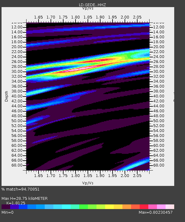
| Estimated Moho Depth: |
28.75 km |
| Estimated Crust Vp/Vs: |
1.81 |
| Assumed Crust Vp: |
6.287 km/s |
| Estimated Crust Vs: |
3.469 km/s |
| Estimated Crust Poisson's Ratio: |
0.28 |
|
| Radial Match: |
94.70851 % |
| Radial Bump: |
179 |
| Transverse Match: |
88.482475 % |
| Transverse Bump: |
299 |
| SOD ConfigId: |
28208852 |
| Insert Time: |
2022-07-26 19:42:46.683 +0000 |
| GWidth: |
2.5 |
| Max Bumps: |
400 |
| Tol: |
0.001 |
|
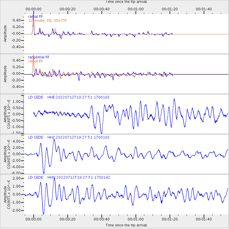
Signal To Noise
| Channel | StoN | STA | LTA |
| LD:GEDE: :HHZ:20220712T19:27:51.170019Z | 11.511665 | 1.3515596E-6 | 1.1740783E-7 |
| LD:GEDE: :HHN:20220712T19:27:51.170019Z | 7.0115976 | 6.0570284E-7 | 8.638585E-8 |
| LD:GEDE: :HHE:20220712T19:27:51.170019Z | 2.5080395 | 2.850307E-7 | 1.13646806E-7 |
| Arrivals |
| Ps | 3.8 SECOND |
| PpPs | 12 SECOND |
| PsPs/PpSs | 16 SECOND |


