You are here: Home > Network List > MB - Montana Regional Seismic Network Stations List
> Station JTMT Jette Lake, Montana > Earthquake Result Viewer
JTMT Jette Lake, Montana - Earthquake Result Viewer
| Earthquake location: |
Easter Island Region |
| Earthquake latitude/longitude: |
-22.6/-114.2 |
| Earthquake time(UTC): |
2022/07/12 (193) 19:17:00 GMT |
| Earthquake Depth: |
10 km |
| Earthquake Magnitude: |
6.4 mb |
| Earthquake Catalog/Contributor: |
NEIC PDE/us |
|
| Network: |
MB Montana Regional Seismic Network |
| Station: |
JTMT Jette Lake, Montana |
| Lat/Lon: |
47.75 N/114.28 W |
| Elevation: |
1469 m |
|
| Distance: |
70.0 deg |
| Az: |
359.937 deg |
| Baz: |
179.914 deg |
| Ray Param: |
0.055273853 |
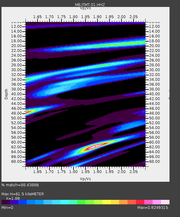
| Estimated Moho Depth: |
61.5 km |
| Estimated Crust Vp/Vs: |
1.89 |
| Assumed Crust Vp: |
6.622 km/s |
| Estimated Crust Vs: |
3.504 km/s |
| Estimated Crust Poisson's Ratio: |
0.31 |
|
| Radial Match: |
88.43886 % |
| Radial Bump: |
184 |
| Transverse Match: |
82.78711 % |
| Transverse Bump: |
394 |
| SOD ConfigId: |
28208852 |
| Insert Time: |
2022-07-26 19:43:12.857 +0000 |
| GWidth: |
2.5 |
| Max Bumps: |
400 |
| Tol: |
0.001 |
|

Signal To Noise
| Channel | StoN | STA | LTA |
| MB:JTMT:01:HHZ:20220712T19:27:40.595007Z | 25.044449 | 1.6800196E-6 | 6.7081515E-8 |
| MB:JTMT:01:HHN:20220712T19:27:40.595007Z | 10.468338 | 8.021489E-7 | 7.662619E-8 |
| MB:JTMT:01:HHE:20220712T19:27:40.595007Z | 1.4926509 | 9.5546675E-8 | 6.40114E-8 |
| Arrivals |
| Ps | 8.6 SECOND |
| PpPs | 26 SECOND |
| PsPs/PpSs | 34 SECOND |


