You are here: Home > Network List > US - United States National Seismic Network Stations List
> Station EGMT Eagleton, Montana, USA > Earthquake Result Viewer
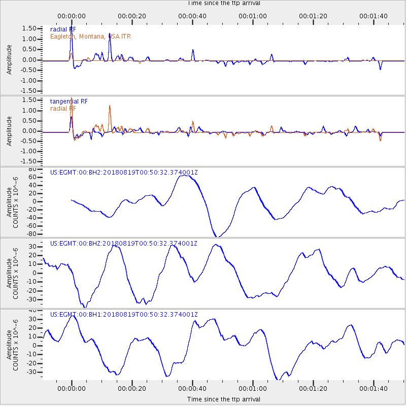
EGMT Eagleton, Montana, USA - Earthquake Result Viewer
*The percent match for this event was below the threshold and hence no stack was calculated.
| Earthquake location: |
Fiji Islands Region |
| Earthquake latitude/longitude: |
-17.9/-178.0 |
| Earthquake time(UTC): |
2018/08/19 (231) 00:39:07 GMT |
| Earthquake Depth: |
576 km |
| Earthquake Magnitude: |
5.7 mb |
| Earthquake Catalog/Contributor: |
NEIC PDE/us |
|
| Network: |
US United States National Seismic Network |
| Station: |
EGMT Eagleton, Montana, USA |
| Lat/Lon: |
48.02 N/109.75 W |
| Elevation: |
1055 m |
|
| Distance: |
89.4 deg |
| Az: |
38.57 deg |
| Baz: |
242.163 deg |
| Ray Param: |
$rayparam |
*The percent match for this event was below the threshold and hence was not used in the summary stack. |
|
| Radial Match: |
69.87102 % |
| Radial Bump: |
287 |
| Transverse Match: |
69.08277 % |
| Transverse Bump: |
400 |
| SOD ConfigId: |
2825771 |
| Insert Time: |
2018-09-02 02:08:10.281 +0000 |
| GWidth: |
2.5 |
| Max Bumps: |
400 |
| Tol: |
0.001 |
|
Signal To Noise
| Channel | StoN | STA | LTA |
| US:EGMT:00:BHZ:20180819T00:50:32.374001Z | 3.4876144 | 2.7024449E-5 | 7.748692E-6 |
| US:EGMT:00:BH1:20180819T00:50:32.374001Z | 2.0096295 | 3.0112924E-5 | 1.4984316E-5 |
| US:EGMT:00:BH2:20180819T00:50:32.374001Z | 1.91796 | 2.8369719E-5 | 1.4791611E-5 |
| Arrivals |
| Ps | |
| PpPs | |
| PsPs/PpSs | |


