You are here: Home > Network List > N4 - Central and EAstern US Network Stations List
> Station Y60A Bolivia, NC, USA > Earthquake Result Viewer
Y60A Bolivia, NC, USA - Earthquake Result Viewer
| Earthquake location: |
Easter Island Region |
| Earthquake latitude/longitude: |
-22.6/-114.2 |
| Earthquake time(UTC): |
2022/07/12 (193) 19:17:00 GMT |
| Earthquake Depth: |
10 km |
| Earthquake Magnitude: |
6.4 mb |
| Earthquake Catalog/Contributor: |
NEIC PDE/us |
|
| Network: |
N4 Central and EAstern US Network |
| Station: |
Y60A Bolivia, NC, USA |
| Lat/Lon: |
34.00 N/78.22 W |
| Elevation: |
7.0 m |
|
| Distance: |
65.9 deg |
| Az: |
32.323 deg |
| Baz: |
216.498 deg |
| Ray Param: |
0.05797477 |
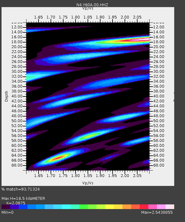
| Estimated Moho Depth: |
16.5 km |
| Estimated Crust Vp/Vs: |
2.10 |
| Assumed Crust Vp: |
6.565 km/s |
| Estimated Crust Vs: |
3.13 km/s |
| Estimated Crust Poisson's Ratio: |
0.35 |
|
| Radial Match: |
93.71324 % |
| Radial Bump: |
400 |
| Transverse Match: |
75.23232 % |
| Transverse Bump: |
400 |
| SOD ConfigId: |
28208852 |
| Insert Time: |
2022-07-26 19:46:21.239 +0000 |
| GWidth: |
2.5 |
| Max Bumps: |
400 |
| Tol: |
0.001 |
|

Signal To Noise
| Channel | StoN | STA | LTA |
| N4:Y60A:00:HHZ:20220712T19:27:14.670019Z | 12.309234 | 2.3927769E-6 | 1.9438878E-7 |
| N4:Y60A:00:HH1:20220712T19:27:14.670019Z | 3.6228533 | 1.7162788E-6 | 4.7373675E-7 |
| N4:Y60A:00:HH2:20220712T19:27:14.670019Z | 2.5951984 | 1.1814648E-6 | 4.552503E-7 |
| Arrivals |
| Ps | 2.9 SECOND |
| PpPs | 7.5 SECOND |
| PsPs/PpSs | 10 SECOND |


