You are here: Home > Network List > NM - Cooperative New Madrid Seismic Network Stations List
> Station HENM Henderson Mound,MO > Earthquake Result Viewer
HENM Henderson Mound,MO - Earthquake Result Viewer
| Earthquake location: |
Easter Island Region |
| Earthquake latitude/longitude: |
-22.6/-114.2 |
| Earthquake time(UTC): |
2022/07/12 (193) 19:17:00 GMT |
| Earthquake Depth: |
10 km |
| Earthquake Magnitude: |
6.4 mb |
| Earthquake Catalog/Contributor: |
NEIC PDE/us |
|
| Network: |
NM Cooperative New Madrid Seismic Network |
| Station: |
HENM Henderson Mound,MO |
| Lat/Lon: |
36.72 N/89.47 W |
| Elevation: |
88 m |
|
| Distance: |
63.4 deg |
| Az: |
22.067 deg |
| Baz: |
205.599 deg |
| Ray Param: |
0.05957604 |
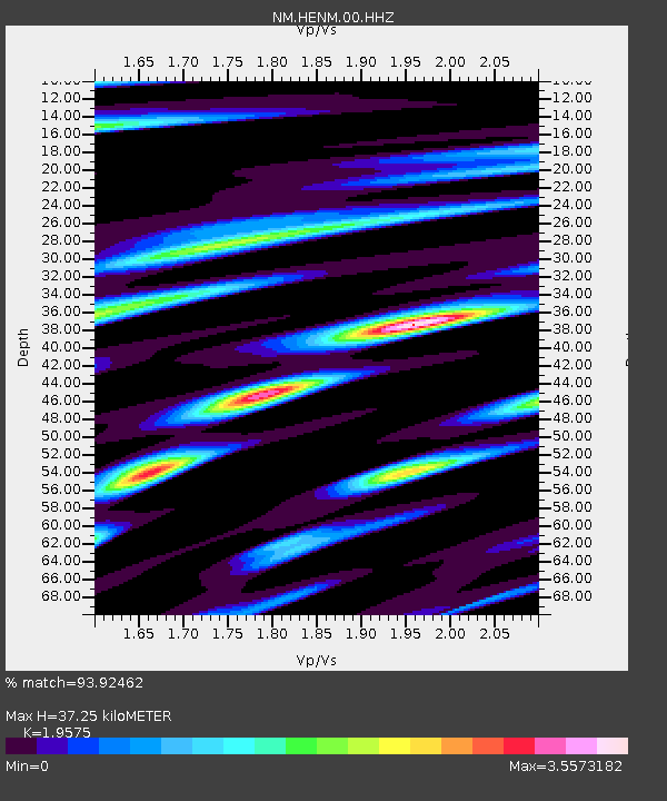
| Estimated Moho Depth: |
37.25 km |
| Estimated Crust Vp/Vs: |
1.96 |
| Assumed Crust Vp: |
6.444 km/s |
| Estimated Crust Vs: |
3.292 km/s |
| Estimated Crust Poisson's Ratio: |
0.32 |
|
| Radial Match: |
93.92462 % |
| Radial Bump: |
304 |
| Transverse Match: |
82.17983 % |
| Transverse Bump: |
321 |
| SOD ConfigId: |
28208852 |
| Insert Time: |
2022-07-26 19:47:27.160 +0000 |
| GWidth: |
2.5 |
| Max Bumps: |
400 |
| Tol: |
0.001 |
|

Signal To Noise
| Channel | StoN | STA | LTA |
| NM:HENM:00:HHZ:20220712T19:26:58.769995Z | 7.6446176 | 3.4534753E-6 | 4.5175253E-7 |
| NM:HENM:00:HHN:20220712T19:26:58.769995Z | 2.6011739 | 1.8895548E-6 | 7.264239E-7 |
| NM:HENM:00:HHE:20220712T19:26:58.769995Z | 1.8090893 | 1.5976179E-6 | 8.8310617E-7 |
| Arrivals |
| Ps | 5.8 SECOND |
| PpPs | 16 SECOND |
| PsPs/PpSs | 22 SECOND |


