You are here: Home > Network List > NN - Western Great Basin/Eastern Sierra Nevada Stations List
> Station WDEM Washoe County DEM, Nevada > Earthquake Result Viewer
WDEM Washoe County DEM, Nevada - Earthquake Result Viewer
| Earthquake location: |
Easter Island Region |
| Earthquake latitude/longitude: |
-22.6/-114.2 |
| Earthquake time(UTC): |
2022/07/12 (193) 19:17:00 GMT |
| Earthquake Depth: |
10 km |
| Earthquake Magnitude: |
6.4 mb |
| Earthquake Catalog/Contributor: |
NEIC PDE/us |
|
| Network: |
NN Western Great Basin/Eastern Sierra Nevada |
| Station: |
WDEM Washoe County DEM, Nevada |
| Lat/Lon: |
39.58 N/119.81 W |
| Elevation: |
1572 m |
|
| Distance: |
62.1 deg |
| Az: |
355.091 deg |
| Baz: |
174.127 deg |
| Ray Param: |
0.06046507 |
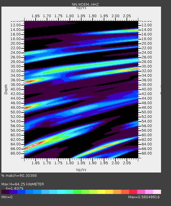
| Estimated Moho Depth: |
64.25 km |
| Estimated Crust Vp/Vs: |
1.64 |
| Assumed Crust Vp: |
6.279 km/s |
| Estimated Crust Vs: |
3.834 km/s |
| Estimated Crust Poisson's Ratio: |
0.20 |
|
| Radial Match: |
90.30388 % |
| Radial Bump: |
347 |
| Transverse Match: |
80.66317 % |
| Transverse Bump: |
400 |
| SOD ConfigId: |
28208852 |
| Insert Time: |
2022-07-26 19:48:36.849 +0000 |
| GWidth: |
2.5 |
| Max Bumps: |
400 |
| Tol: |
0.001 |
|

Signal To Noise
| Channel | StoN | STA | LTA |
| NN:WDEM: :HHZ:20220712T19:26:49.697973Z | 4.852924 | 5.722648E-7 | 1.1792165E-7 |
| NN:WDEM: :HHN:20220712T19:26:49.697973Z | 2.0033784 | 4.3565072E-7 | 2.1745804E-7 |
| NN:WDEM: :HHE:20220712T19:26:49.697973Z | 1.3166556 | 2.1295796E-7 | 1.6174158E-7 |
| Arrivals |
| Ps | 6.8 SECOND |
| PpPs | 26 SECOND |
| PsPs/PpSs | 33 SECOND |


