You are here: Home > Network List > O2 - Oklahoma Consolidated Temporary Seismic Networks Stations List
> Station FW06 Aline, Oklahoma, USA > Earthquake Result Viewer
FW06 Aline, Oklahoma, USA - Earthquake Result Viewer
| Earthquake location: |
Easter Island Region |
| Earthquake latitude/longitude: |
-22.6/-114.2 |
| Earthquake time(UTC): |
2022/07/12 (193) 19:17:00 GMT |
| Earthquake Depth: |
10 km |
| Earthquake Magnitude: |
6.4 mb |
| Earthquake Catalog/Contributor: |
NEIC PDE/us |
|
| Network: |
O2 Oklahoma Consolidated Temporary Seismic Networks |
| Station: |
FW06 Aline, Oklahoma, USA |
| Lat/Lon: |
36.51 N/98.50 W |
| Elevation: |
420 m |
|
| Distance: |
60.6 deg |
| Az: |
14.482 deg |
| Baz: |
196.67 deg |
| Ray Param: |
0.061414454 |
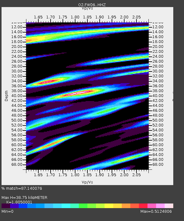
| Estimated Moho Depth: |
38.75 km |
| Estimated Crust Vp/Vs: |
1.81 |
| Assumed Crust Vp: |
6.426 km/s |
| Estimated Crust Vs: |
3.56 km/s |
| Estimated Crust Poisson's Ratio: |
0.28 |
|
| Radial Match: |
87.140076 % |
| Radial Bump: |
348 |
| Transverse Match: |
70.82123 % |
| Transverse Bump: |
400 |
| SOD ConfigId: |
28208852 |
| Insert Time: |
2022-07-26 19:49:42.375 +0000 |
| GWidth: |
2.5 |
| Max Bumps: |
400 |
| Tol: |
0.001 |
|

Signal To Noise
| Channel | StoN | STA | LTA |
| O2:FW06: :HHZ:20220712T19:26:39.939978Z | 28.529821 | 3.7667514E-6 | 1.3202856E-7 |
| O2:FW06: :HHN:20220712T19:26:39.939978Z | 12.58713 | 1.4974072E-6 | 1.18963364E-7 |
| O2:FW06: :HHE:20220712T19:26:39.939978Z | 0.69574356 | 4.3169527E-7 | 6.204804E-7 |
| Arrivals |
| Ps | 5.1 SECOND |
| PpPs | 16 SECOND |
| PsPs/PpSs | 21 SECOND |


