You are here: Home > Network List > O2 - Oklahoma Consolidated Temporary Seismic Networks Stations List
> Station FW09 Waynoka, Oklahoma, USA > Earthquake Result Viewer
FW09 Waynoka, Oklahoma, USA - Earthquake Result Viewer
| Earthquake location: |
Easter Island Region |
| Earthquake latitude/longitude: |
-22.6/-114.2 |
| Earthquake time(UTC): |
2022/07/12 (193) 19:17:00 GMT |
| Earthquake Depth: |
10 km |
| Earthquake Magnitude: |
6.4 mb |
| Earthquake Catalog/Contributor: |
NEIC PDE/us |
|
| Network: |
O2 Oklahoma Consolidated Temporary Seismic Networks |
| Station: |
FW09 Waynoka, Oklahoma, USA |
| Lat/Lon: |
36.55 N/99.04 W |
| Elevation: |
517 m |
|
| Distance: |
60.5 deg |
| Az: |
13.99 deg |
| Baz: |
196.107 deg |
| Ray Param: |
0.061471943 |
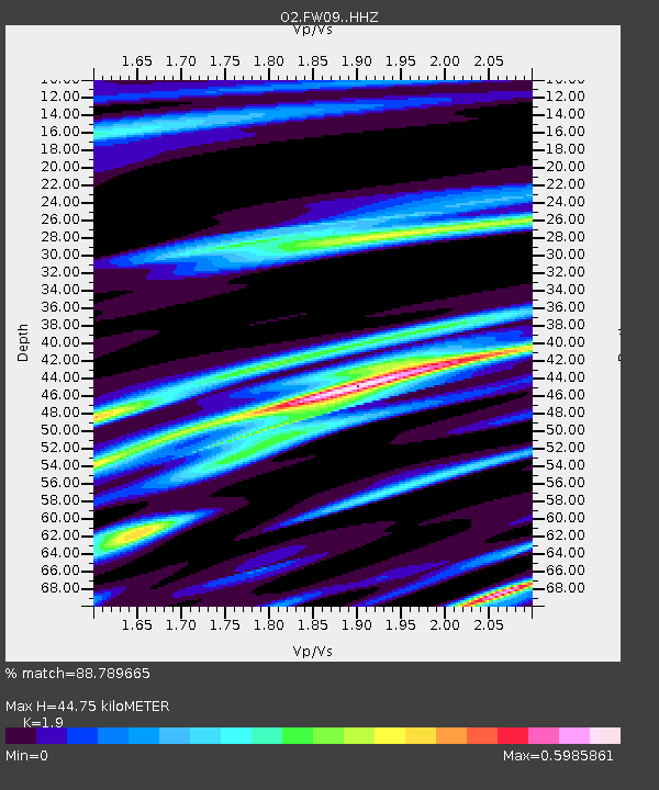
| Estimated Moho Depth: |
44.75 km |
| Estimated Crust Vp/Vs: |
1.90 |
| Assumed Crust Vp: |
6.426 km/s |
| Estimated Crust Vs: |
3.382 km/s |
| Estimated Crust Poisson's Ratio: |
0.31 |
|
| Radial Match: |
88.789665 % |
| Radial Bump: |
260 |
| Transverse Match: |
88.78532 % |
| Transverse Bump: |
256 |
| SOD ConfigId: |
28208852 |
| Insert Time: |
2022-07-26 19:49:44.834 +0000 |
| GWidth: |
2.5 |
| Max Bumps: |
400 |
| Tol: |
0.001 |
|

Signal To Noise
| Channel | StoN | STA | LTA |
| O2:FW09: :HHZ:20220712T19:26:39.340002Z | 30.783941 | 3.6347453E-6 | 1.1807277E-7 |
| O2:FW09: :HHN:20220712T19:26:39.340002Z | 8.567694 | 1.0860628E-6 | 1.2676256E-7 |
| $trig.getChannelId() | $trig.getValue() | $trig.getSTA() | $trig.getLTA() |
| Arrivals |
| Ps | 6.5 SECOND |
| PpPs | 19 SECOND |
| PsPs/PpSs | 26 SECOND |


