You are here: Home > Network List > TW - Broadband Array in Taiwan for Seismology Stations List
> Station YULB YU-LI > Earthquake Result Viewer
YULB YU-LI - Earthquake Result Viewer
| Earthquake location: |
Flores Sea |
| Earthquake latitude/longitude: |
-7.2/120.1 |
| Earthquake time(UTC): |
2006/09/09 (252) 04:13:12 GMT |
| Earthquake Depth: |
572 km |
| Earthquake Magnitude: |
6.0 MB, 6.3 MW, 6.3 MW |
| Earthquake Catalog/Contributor: |
WHDF/NEIC |
|
| Network: |
TW Broadband Array in Taiwan for Seismology |
| Station: |
YULB YU-LI |
| Lat/Lon: |
23.39 N/121.30 E |
| Elevation: |
295 m |
|
| Distance: |
30.4 deg |
| Az: |
2.161 deg |
| Baz: |
182.334 deg |
| Ray Param: |
0.07697675 |
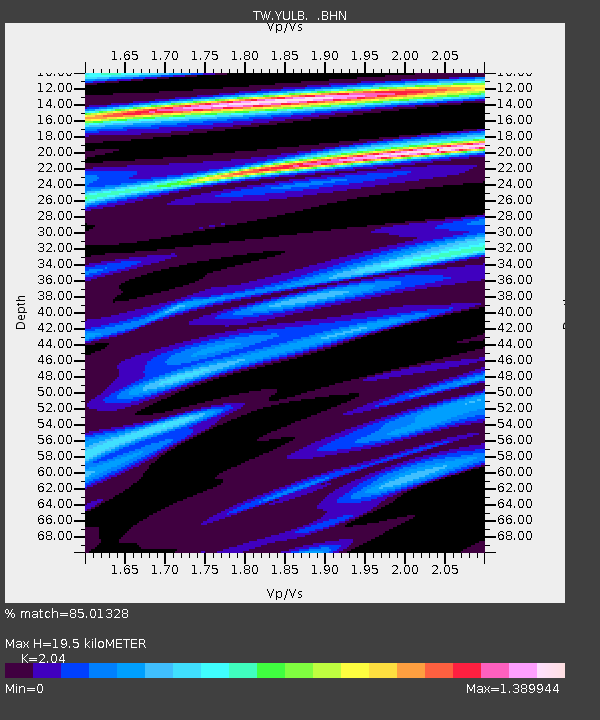
| Estimated Moho Depth: |
19.5 km |
| Estimated Crust Vp/Vs: |
2.04 |
| Assumed Crust Vp: |
6.461 km/s |
| Estimated Crust Vs: |
3.167 km/s |
| Estimated Crust Poisson's Ratio: |
0.34 |
|
| Radial Match: |
85.01328 % |
| Radial Bump: |
400 |
| Transverse Match: |
70.29619 % |
| Transverse Bump: |
400 |
| SOD ConfigId: |
2564 |
| Insert Time: |
2010-03-09 22:21:56.197 +0000 |
| GWidth: |
2.5 |
| Max Bumps: |
400 |
| Tol: |
0.001 |
|

Signal To Noise
| Channel | StoN | STA | LTA |
| TW:YULB: :BHN:20060909T04:18:08.570009Z | 8.824156 | 9.305823E-7 | 1.0545851E-7 |
| TW:YULB: :BHE:20060909T04:18:08.570009Z | 12.450112 | 9.390499E-7 | 7.542502E-8 |
| TW:YULB: :BHZ:20060909T04:18:08.570009Z | 11.251143 | 1.4186331E-6 | 1.260879E-7 |
| Arrivals |
| Ps | 3.4 SECOND |
| PpPs | 8.6 SECOND |
| PsPs/PpSs | 12 SECOND |


