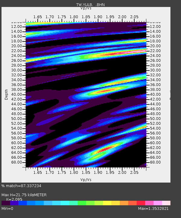
YULB YU-LI - Earthquake Result Viewer

Earthquake location: Sunda Strait, Indonesia
Earthquake latitude/longitude: -6.5/105.4
Earthquake time(UTC): 2006/07/19 (200) 10:57:36 GMT
Earthquake Depth: 45 km
Earthquake Magnitude: 5.6 MB, 6.0 MS, 6.1 MW, 6.1 MW
Earthquake Catalog/Contributor: WHDF/NEIC
Network: TW Broadband Array in Taiwan for Seismology
Station: YULB YU-LI
Lat/Lon: 23.39 N/121.30 E
Elevation: 295 m
Distance: 33.6 deg
Az: 27.099 deg
Baz: 209.513 deg
Ray Param: 0.07805841
Estimated Moho Depth: 21.75 km
Estimated Crust Vp/Vs: 2.10
Assumed Crust Vp: 6.461 km/s
Estimated Crust Vs: 3.084 km/s
Estimated Crust Poisson's Ratio: 0.35
Radial Match: 87.337234 %
Radial Bump: 400
Transverse Match: 77.49343 %
Transverse Bump: 400
SOD ConfigId: 5423
Insert Time: 2010-03-09 22:22:11.625 +0000
GWidth: 2.5
Max Bumps: 400
Tol: 0.001

Signal To Noise

ChannelStoNSTALTA
TW:YULB: :BHN:20060719T11:03:42.270015Z5.79633474.0387016E-76.9676815E-8
TW:YULB: :BHE:20060719T11:03:42.270015Z2.08460931.7407275E-78.350378E-8
TW:YULB: :BHZ:20060719T11:03:42.270015Z4.86464936.816703E-71.4012733E-7
Arrivals
Ps3.9 SECOND
PpPs9.8 SECOND
PsPs/PpSs14 SECOND