You are here: Home > Network List > TX - Texas Seismological Network Stations List
> Station PB05 Z > Earthquake Result Viewer
PB05 Z - Earthquake Result Viewer
| Earthquake location: |
Easter Island Region |
| Earthquake latitude/longitude: |
-22.6/-114.2 |
| Earthquake time(UTC): |
2022/07/12 (193) 19:17:00 GMT |
| Earthquake Depth: |
10 km |
| Earthquake Magnitude: |
6.4 mb |
| Earthquake Catalog/Contributor: |
NEIC PDE/us |
|
| Network: |
TX Texas Seismological Network |
| Station: |
PB05 Z |
| Lat/Lon: |
30.92 N/103.32 W |
| Elevation: |
957 m |
|
| Distance: |
54.2 deg |
| Az: |
11.523 deg |
| Baz: |
192.403 deg |
| Ray Param: |
0.06559146 |
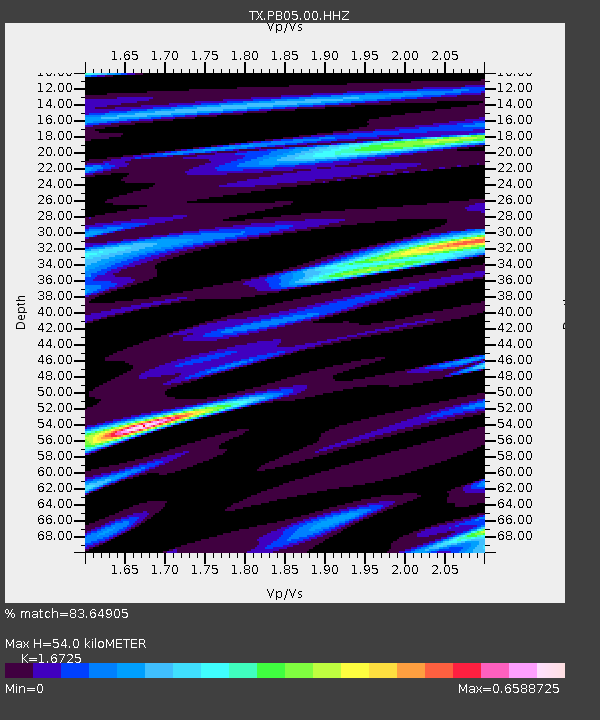
| Estimated Moho Depth: |
54.0 km |
| Estimated Crust Vp/Vs: |
1.67 |
| Assumed Crust Vp: |
6.121 km/s |
| Estimated Crust Vs: |
3.659 km/s |
| Estimated Crust Poisson's Ratio: |
0.22 |
|
| Radial Match: |
83.64905 % |
| Radial Bump: |
282 |
| Transverse Match: |
81.54127 % |
| Transverse Bump: |
299 |
| SOD ConfigId: |
28208852 |
| Insert Time: |
2022-07-26 19:58:12.041 +0000 |
| GWidth: |
2.5 |
| Max Bumps: |
400 |
| Tol: |
0.001 |
|

Signal To Noise
| Channel | StoN | STA | LTA |
| TX:PB05:00:HHZ:20220712T19:25:54.819982Z | 8.380024 | 9.4585744E-7 | 1.1287049E-7 |
| TX:PB05:00:HH1:20220712T19:25:54.819982Z | 10.185824 | 3.2813773E-7 | 3.2215137E-8 |
| TX:PB05:00:HH2:20220712T19:25:54.819982Z | 3.084153 | 1.9113142E-7 | 6.1972095E-8 |
| Arrivals |
| Ps | 6.2 SECOND |
| PpPs | 22 SECOND |
| PsPs/PpSs | 29 SECOND |


