You are here: Home > Network List > TX - Texas Seismological Network Stations List
> Station SNAG San Augustine > Earthquake Result Viewer
SNAG San Augustine - Earthquake Result Viewer
| Earthquake location: |
Easter Island Region |
| Earthquake latitude/longitude: |
-22.6/-114.2 |
| Earthquake time(UTC): |
2022/07/12 (193) 19:17:00 GMT |
| Earthquake Depth: |
10 km |
| Earthquake Magnitude: |
6.4 mb |
| Earthquake Catalog/Contributor: |
NEIC PDE/us |
|
| Network: |
TX Texas Seismological Network |
| Station: |
SNAG San Augustine |
| Lat/Lon: |
31.52 N/94.18 W |
| Elevation: |
84 m |
|
| Distance: |
57.1 deg |
| Az: |
20.368 deg |
| Baz: |
202.124 deg |
| Ray Param: |
0.063681126 |
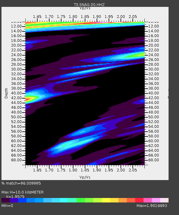
| Estimated Moho Depth: |
10.0 km |
| Estimated Crust Vp/Vs: |
1.96 |
| Assumed Crust Vp: |
5.738 km/s |
| Estimated Crust Vs: |
2.932 km/s |
| Estimated Crust Poisson's Ratio: |
0.32 |
|
| Radial Match: |
96.009995 % |
| Radial Bump: |
213 |
| Transverse Match: |
84.55007 % |
| Transverse Bump: |
341 |
| SOD ConfigId: |
28208852 |
| Insert Time: |
2022-07-26 19:59:00.216 +0000 |
| GWidth: |
2.5 |
| Max Bumps: |
400 |
| Tol: |
0.001 |
|
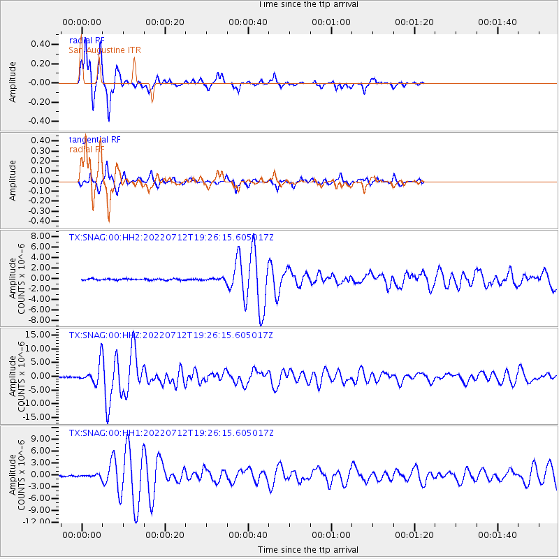
Signal To Noise
| Channel | StoN | STA | LTA |
| TX:SNAG:00:HHZ:20220712T19:26:15.605017Z | 31.344053 | 3.678227E-6 | 1.17350076E-7 |
| TX:SNAG:00:HH1:20220712T19:26:15.605017Z | 2.8589509 | 2.855355E-7 | 9.987423E-8 |
| TX:SNAG:00:HH2:20220712T19:26:15.605017Z | 1.7710922 | 2.1679224E-7 | 1.2240596E-7 |
| Arrivals |
| Ps | 1.7 SECOND |
| PpPs | 5.0 SECOND |
| PsPs/PpSs | 6.7 SECOND |


