You are here: Home > Network List > TX - Texas Seismological Network Stations List
> Station MB09 Lenorah > Earthquake Result Viewer
MB09 Lenorah - Earthquake Result Viewer
| Earthquake location: |
Easter Island Region |
| Earthquake latitude/longitude: |
-22.6/-114.2 |
| Earthquake time(UTC): |
2022/07/12 (193) 19:17:00 GMT |
| Earthquake Depth: |
10 km |
| Earthquake Magnitude: |
6.4 mb |
| Earthquake Catalog/Contributor: |
NEIC PDE/us |
|
| Network: |
TX Texas Seismological Network |
| Station: |
MB09 Lenorah |
| Lat/Lon: |
32.34 N/101.82 W |
| Elevation: |
798 m |
|
| Distance: |
55.9 deg |
| Az: |
12.656 deg |
| Baz: |
193.838 deg |
| Ray Param: |
0.064505614 |
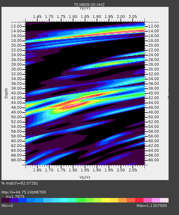
| Estimated Moho Depth: |
44.75 km |
| Estimated Crust Vp/Vs: |
1.80 |
| Assumed Crust Vp: |
6.426 km/s |
| Estimated Crust Vs: |
3.575 km/s |
| Estimated Crust Poisson's Ratio: |
0.28 |
|
| Radial Match: |
92.07261 % |
| Radial Bump: |
400 |
| Transverse Match: |
83.67869 % |
| Transverse Bump: |
400 |
| SOD ConfigId: |
28208852 |
| Insert Time: |
2022-07-26 19:59:06.731 +0000 |
| GWidth: |
2.5 |
| Max Bumps: |
400 |
| Tol: |
0.001 |
|

Signal To Noise
| Channel | StoN | STA | LTA |
| TX:MB09:00:HHZ:20220712T19:26:06.860021Z | 16.741796 | 3.980397E-6 | 2.3775212E-7 |
| TX:MB09:00:HHN:20220712T19:26:06.860021Z | 4.100151 | 1.475078E-6 | 3.5976186E-7 |
| TX:MB09:00:HHE:20220712T19:26:06.860021Z | 1.7129765 | 3.7455413E-7 | 2.1865692E-7 |
| Arrivals |
| Ps | 5.8 SECOND |
| PpPs | 19 SECOND |
| PsPs/PpSs | 24 SECOND |


