You are here: Home > Network List > UO - University of Oregon Regional Network Stations List
> Station TRASK Tillamook, OR, USA > Earthquake Result Viewer
TRASK Tillamook, OR, USA - Earthquake Result Viewer
| Earthquake location: |
Easter Island Region |
| Earthquake latitude/longitude: |
-22.6/-114.2 |
| Earthquake time(UTC): |
2022/07/12 (193) 19:17:00 GMT |
| Earthquake Depth: |
10 km |
| Earthquake Magnitude: |
6.4 mb |
| Earthquake Catalog/Contributor: |
NEIC PDE/us |
|
| Network: |
UO University of Oregon Regional Network |
| Station: |
TRASK Tillamook, OR, USA |
| Lat/Lon: |
45.39 N/123.52 W |
| Elevation: |
786 m |
|
| Distance: |
68.2 deg |
| Az: |
352.933 deg |
| Baz: |
170.715 deg |
| Ray Param: |
0.056465827 |
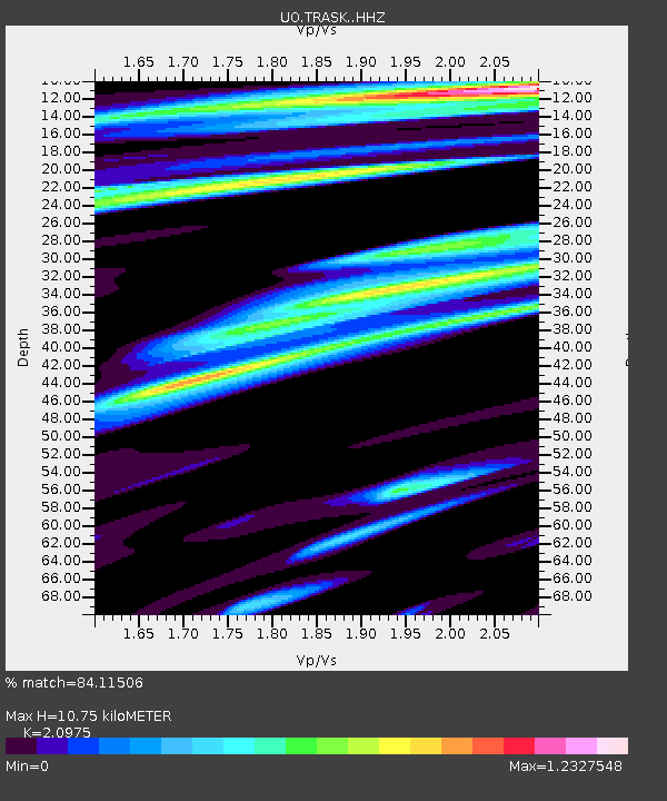
| Estimated Moho Depth: |
10.75 km |
| Estimated Crust Vp/Vs: |
2.10 |
| Assumed Crust Vp: |
6.566 km/s |
| Estimated Crust Vs: |
3.13 km/s |
| Estimated Crust Poisson's Ratio: |
0.35 |
|
| Radial Match: |
84.11506 % |
| Radial Bump: |
381 |
| Transverse Match: |
77.02554 % |
| Transverse Bump: |
400 |
| SOD ConfigId: |
28208852 |
| Insert Time: |
2022-07-26 20:00:10.613 +0000 |
| GWidth: |
2.5 |
| Max Bumps: |
400 |
| Tol: |
0.001 |
|

Signal To Noise
| Channel | StoN | STA | LTA |
| UO:TRASK: :HHZ:20220712T19:27:29.290014Z | 3.3479006 | 1.4856828E-6 | 4.4376552E-7 |
| UO:TRASK: :HHN:20220712T19:27:29.290014Z | 0.8700987 | 4.6551625E-7 | 5.3501543E-7 |
| UO:TRASK: :HHE:20220712T19:27:29.290014Z | 1.0474225 | 5.6559134E-7 | 5.399839E-7 |
| Arrivals |
| Ps | 1.9 SECOND |
| PpPs | 4.9 SECOND |
| PsPs/PpSs | 6.8 SECOND |


