You are here: Home > Network List > UU - University of Utah Regional Network Stations List
> Station CTU Camp Tracy, UT, USA > Earthquake Result Viewer
CTU Camp Tracy, UT, USA - Earthquake Result Viewer
| Earthquake location: |
Easter Island Region |
| Earthquake latitude/longitude: |
-22.6/-114.2 |
| Earthquake time(UTC): |
2022/07/12 (193) 19:17:00 GMT |
| Earthquake Depth: |
10 km |
| Earthquake Magnitude: |
6.4 mb |
| Earthquake Catalog/Contributor: |
NEIC PDE/us |
|
| Network: |
UU University of Utah Regional Network |
| Station: |
CTU Camp Tracy, UT, USA |
| Lat/Lon: |
40.69 N/111.75 W |
| Elevation: |
1731 m |
|
| Distance: |
63.0 deg |
| Az: |
2.086 deg |
| Baz: |
182.535 deg |
| Ray Param: |
0.05984966 |
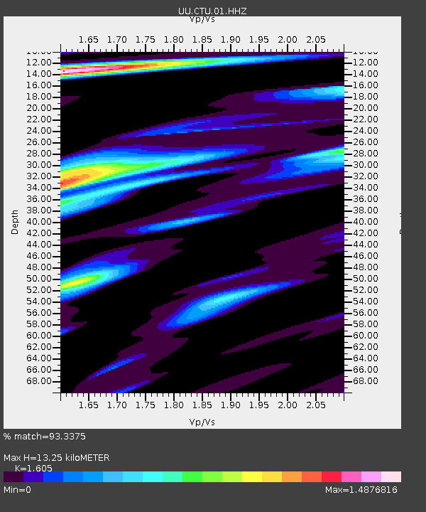
| Estimated Moho Depth: |
13.25 km |
| Estimated Crust Vp/Vs: |
1.61 |
| Assumed Crust Vp: |
6.155 km/s |
| Estimated Crust Vs: |
3.835 km/s |
| Estimated Crust Poisson's Ratio: |
0.18 |
|
| Radial Match: |
93.3375 % |
| Radial Bump: |
400 |
| Transverse Match: |
91.2353 % |
| Transverse Bump: |
368 |
| SOD ConfigId: |
28208852 |
| Insert Time: |
2022-07-26 20:02:07.857 +0000 |
| GWidth: |
2.5 |
| Max Bumps: |
400 |
| Tol: |
0.001 |
|

Signal To Noise
| Channel | StoN | STA | LTA |
| UU:CTU:01:HHZ:20220712T19:26:55.86997Z | 16.927187 | 1.0724335E-8 | 6.335568E-10 |
| UU:CTU:01:HHN:20220712T19:26:55.86997Z | 1.6676024 | 3.408767E-9 | 2.0441127E-9 |
| UU:CTU:01:HHE:20220712T19:26:55.86997Z | 1.2277886 | 1.6678798E-9 | 1.3584422E-9 |
| Arrivals |
| Ps | 1.4 SECOND |
| PpPs | 5.4 SECOND |
| PsPs/PpSs | 6.7 SECOND |


