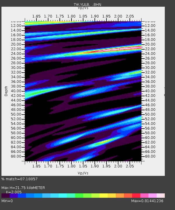
YULB YU-LI - Earthquake Result Viewer

Earthquake location: New Britain Region, P.N.G.
Earthquake latitude/longitude: -5.5/151.8
Earthquake time(UTC): 2000/11/17 (322) 21:01:56 GMT
Earthquake Depth: 33 km
Earthquake Magnitude: 6.2 MB, 8.0 MS, 7.6 MW, 6.9 ME
Earthquake Catalog/Contributor: WHDF/NEIC
Network: TW Broadband Array in Taiwan for Seismology
Station: YULB YU-LI
Lat/Lon: 23.39 N/121.30 E
Elevation: 295 m
Distance: 41.4 deg
Az: 315.137 deg
Baz: 130.156 deg
Ray Param: 0.07377637
Estimated Moho Depth: 21.75 km
Estimated Crust Vp/Vs: 2.01
Assumed Crust Vp: 6.461 km/s
Estimated Crust Vs: 3.223 km/s
Estimated Crust Poisson's Ratio: 0.33
Radial Match: 87.18857 %
Radial Bump: 320
Transverse Match: 77.86876 %
Transverse Bump: 400
SOD ConfigId: 3744
Insert Time: 2010-03-09 22:22:55.948 +0000
GWidth: 2.5
Max Bumps: 400
Tol: 0.001

Signal To Noise

ChannelStoNSTALTA
TW:YULB: :BHN:20001117T21:09:08.831003Z1.5152647.462851E-74.925116E-7
TW:YULB: :BHE:20001117T21:09:08.831003Z1.16140315.7270375E-74.9311365E-7
TW:YULB: :BHZ:20001117T21:09:08.831003Z3.67338421.9380598E-65.275952E-7
Arrivals
Ps3.6 SECOND
PpPs9.5 SECOND
PsPs/PpSs13 SECOND