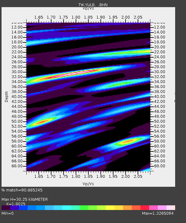
YULB YU-LI - Earthquake Result Viewer

Earthquake location: South Indian Ocean
Earthquake latitude/longitude: -13.8/97.5
Earthquake time(UTC): 2000/06/18 (170) 14:44:13 GMT
Earthquake Depth: 10 km
Earthquake Magnitude: 6.8 MB, 7.8 MS, 7.8 MW, 7.6 MW
Earthquake Catalog/Contributor: WHDF/NEIC
Network: TW Broadband Array in Taiwan for Seismology
Station: YULB YU-LI
Lat/Lon: 23.39 N/121.30 E
Elevation: 295 m
Distance: 43.7 deg
Az: 32.512 deg
Baz: 214.633 deg
Ray Param: 0.07237395
Estimated Moho Depth: 30.25 km
Estimated Crust Vp/Vs: 1.80
Assumed Crust Vp: 6.461 km/s
Estimated Crust Vs: 3.585 km/s
Estimated Crust Poisson's Ratio: 0.28
Radial Match: 90.665245 %
Radial Bump: 396
Transverse Match: 86.19069 %
Transverse Bump: 400
SOD ConfigId: 3744
Insert Time: 2010-03-09 22:23:13.510 +0000
GWidth: 2.5
Max Bumps: 400
Tol: 0.001

Signal To Noise

ChannelStoNSTALTA
TW:YULB: :BHN:20000618T14:51:47.588015Z3.00486142.530481E-68.4212905E-7
TW:YULB: :BHE:20000618T14:51:47.588015Z2.01619391.4632759E-67.257615E-7
TW:YULB: :BHZ:20000618T14:51:47.588015Z5.1472437.041818E-61.3680758E-6
Arrivals
Ps4.0 SECOND
PpPs12 SECOND
PsPs/PpSs16 SECOND