You are here: Home > Network List > TX - Texas Seismological Network Stations List
> Station PB01 Permian Basin 1 > Earthquake Result Viewer
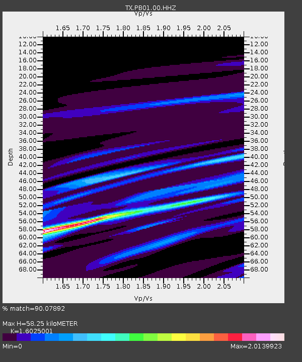
PB01 Permian Basin 1 - Earthquake Result Viewer
| Earthquake location: |
Fiji Islands Region |
| Earthquake latitude/longitude: |
-18.3/-178.4 |
| Earthquake time(UTC): |
2018/08/19 (231) 02:18:52 GMT |
| Earthquake Depth: |
618 km |
| Earthquake Magnitude: |
5.7 mb |
| Earthquake Catalog/Contributor: |
NEIC PDE/us |
|
| Network: |
TX Texas Seismological Network |
| Station: |
PB01 Permian Basin 1 |
| Lat/Lon: |
30.94 N/103.78 W |
| Elevation: |
1010 m |
|
| Distance: |
86.7 deg |
| Az: |
56.059 deg |
| Baz: |
246.56 deg |
| Ray Param: |
0.042062677 |
| Estimated Moho Depth: |
58.25 km |
| Estimated Crust Vp/Vs: |
1.60 |
| Assumed Crust Vp: |
6.121 km/s |
| Estimated Crust Vs: |
3.819 km/s |
| Estimated Crust Poisson's Ratio: |
0.18 |
|
| Radial Match: |
90.07892 % |
| Radial Bump: |
337 |
| Transverse Match: |
59.84886 % |
| Transverse Bump: |
400 |
| SOD ConfigId: |
2825771 |
| Insert Time: |
2018-09-02 02:27:43.030 +0000 |
| GWidth: |
2.5 |
| Max Bumps: |
400 |
| Tol: |
0.001 |
|

Signal To Noise
| Channel | StoN | STA | LTA |
| TX:PB01:00:HHZ:20180819T02:30:00.959995Z | 2.1852486 | 2.8215607E-6 | 1.2911852E-6 |
| TX:PB01:00:HH1:20180819T02:30:00.959995Z | 2.0054498 | 1.9178178E-6 | 9.563031E-7 |
| TX:PB01:00:HH2:20180819T02:30:00.959995Z | 0.295415 | 2.9685123E-7 | 1.0048617E-6 |
| Arrivals |
| Ps | 5.9 SECOND |
| PpPs | 24 SECOND |
| PsPs/PpSs | 30 SECOND |


