You are here: Home > Network List > TW - Broadband Array in Taiwan for Seismology Stations List
> Station YULB YU-LI > Earthquake Result Viewer
YULB YU-LI - Earthquake Result Viewer
| Earthquake location: |
Central Alaska |
| Earthquake latitude/longitude: |
63.5/-147.4 |
| Earthquake time(UTC): |
2002/11/03 (307) 22:12:41 GMT |
| Earthquake Depth: |
4.9 km |
| Earthquake Magnitude: |
7.0 MB, 8.5 MS, 7.9 MW |
| Earthquake Catalog/Contributor: |
WHDF/NEIC |
|
| Network: |
TW Broadband Array in Taiwan for Seismology |
| Station: |
YULB YU-LI |
| Lat/Lon: |
23.39 N/121.30 E |
| Elevation: |
295 m |
|
| Distance: |
69.9 deg |
| Az: |
281.988 deg |
| Baz: |
28.511 deg |
| Ray Param: |
0.05535718 |
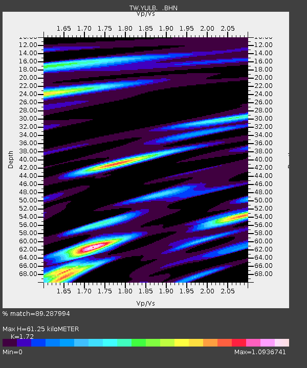
| Estimated Moho Depth: |
61.25 km |
| Estimated Crust Vp/Vs: |
1.72 |
| Assumed Crust Vp: |
6.461 km/s |
| Estimated Crust Vs: |
3.757 km/s |
| Estimated Crust Poisson's Ratio: |
0.24 |
|
| Radial Match: |
89.287994 % |
| Radial Bump: |
400 |
| Transverse Match: |
85.85776 % |
| Transverse Bump: |
400 |
| SOD ConfigId: |
4714 |
| Insert Time: |
2010-03-09 22:24:15.224 +0000 |
| GWidth: |
2.5 |
| Max Bumps: |
400 |
| Tol: |
0.001 |
|

Signal To Noise
| Channel | StoN | STA | LTA |
| TW:YULB: :BHN:20021103T22:23:21.614014Z | 4.075748 | 1.4701712E-6 | 3.60712E-7 |
| TW:YULB: :BHE:20021103T22:23:21.614014Z | 4.8104496 | 1.649452E-6 | 3.4288936E-7 |
| TW:YULB: :BHZ:20021103T22:23:21.614014Z | 9.388425 | 4.1290973E-6 | 4.3980728E-7 |
| Arrivals |
| Ps | 7.1 SECOND |
| PpPs | 25 SECOND |
| PsPs/PpSs | 32 SECOND |


