You are here: Home > Network List > N4 - Central and EAstern US Network Stations List
> Station N47A Urbana, IN, USA > Earthquake Result Viewer
N47A Urbana, IN, USA - Earthquake Result Viewer
| Earthquake location: |
Easter Island Region |
| Earthquake latitude/longitude: |
-22.5/-114.0 |
| Earthquake time(UTC): |
2022/07/12 (193) 21:47:57 GMT |
| Earthquake Depth: |
10 km |
| Earthquake Magnitude: |
5.5 mb |
| Earthquake Catalog/Contributor: |
NEIC PDE/us |
|
| Network: |
N4 Central and EAstern US Network |
| Station: |
N47A Urbana, IN, USA |
| Lat/Lon: |
40.88 N/85.69 W |
| Elevation: |
252 m |
|
| Distance: |
68.3 deg |
| Az: |
22.801 deg |
| Baz: |
208.212 deg |
| Ray Param: |
0.056383565 |
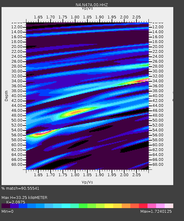
| Estimated Moho Depth: |
33.25 km |
| Estimated Crust Vp/Vs: |
2.10 |
| Assumed Crust Vp: |
6.498 km/s |
| Estimated Crust Vs: |
3.098 km/s |
| Estimated Crust Poisson's Ratio: |
0.35 |
|
| Radial Match: |
90.55541 % |
| Radial Bump: |
400 |
| Transverse Match: |
70.63792 % |
| Transverse Bump: |
400 |
| SOD ConfigId: |
28208852 |
| Insert Time: |
2022-07-26 22:08:29.332 +0000 |
| GWidth: |
2.5 |
| Max Bumps: |
400 |
| Tol: |
0.001 |
|

Signal To Noise
| Channel | StoN | STA | LTA |
| N4:N47A:00:HHZ:20220712T21:58:27.230015Z | 2.5662951 | 4.1617457E-7 | 1.6216941E-7 |
| N4:N47A:00:HH1:20220712T21:58:27.230015Z | 1.6048753 | 2.302365E-7 | 1.4346067E-7 |
| N4:N47A:00:HH2:20220712T21:58:27.230015Z | 1.4787153 | 1.5451293E-7 | 1.0449133E-7 |
| Arrivals |
| Ps | 5.8 SECOND |
| PpPs | 15 SECOND |
| PsPs/PpSs | 21 SECOND |


