You are here: Home > Network List > TX - Texas Seismological Network Stations List
> Station MNHN Monahans > Earthquake Result Viewer
MNHN Monahans - Earthquake Result Viewer
| Earthquake location: |
Easter Island Region |
| Earthquake latitude/longitude: |
-22.5/-114.0 |
| Earthquake time(UTC): |
2022/07/12 (193) 21:47:57 GMT |
| Earthquake Depth: |
10 km |
| Earthquake Magnitude: |
5.5 mb |
| Earthquake Catalog/Contributor: |
NEIC PDE/us |
|
| Network: |
TX Texas Seismological Network |
| Station: |
MNHN Monahans |
| Lat/Lon: |
31.34 N/102.76 W |
| Elevation: |
750 m |
|
| Distance: |
54.6 deg |
| Az: |
11.858 deg |
| Baz: |
192.834 deg |
| Ray Param: |
0.06535892 |
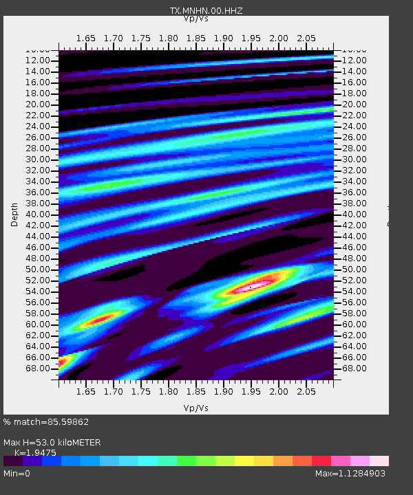
| Estimated Moho Depth: |
53.0 km |
| Estimated Crust Vp/Vs: |
1.95 |
| Assumed Crust Vp: |
6.121 km/s |
| Estimated Crust Vs: |
3.143 km/s |
| Estimated Crust Poisson's Ratio: |
0.32 |
|
| Radial Match: |
85.59862 % |
| Radial Bump: |
377 |
| Transverse Match: |
40.69761 % |
| Transverse Bump: |
400 |
| SOD ConfigId: |
28208852 |
| Insert Time: |
2022-07-26 22:17:48.613 +0000 |
| GWidth: |
2.5 |
| Max Bumps: |
400 |
| Tol: |
0.001 |
|

Signal To Noise
| Channel | StoN | STA | LTA |
| TX:MNHN:00:HHZ:20220712T21:56:54.60001Z | 3.1176746 | 5.1261026E-7 | 1.644207E-7 |
| TX:MNHN:00:HH1:20220712T21:56:54.60001Z | 2.1755514 | 1.9676834E-7 | 9.044527E-8 |
| TX:MNHN:00:HH2:20220712T21:56:54.60001Z | 1.6349247 | 2.9043548E-7 | 1.7764457E-7 |
| Arrivals |
| Ps | 8.6 SECOND |
| PpPs | 24 SECOND |
| PsPs/PpSs | 33 SECOND |


