You are here: Home > Network List > UU - University of Utah Regional Network Stations List
> Station CCUT Cedar City, UT, USA > Earthquake Result Viewer
CCUT Cedar City, UT, USA - Earthquake Result Viewer
| Earthquake location: |
Easter Island Region |
| Earthquake latitude/longitude: |
-22.5/-114.0 |
| Earthquake time(UTC): |
2022/07/12 (193) 21:47:57 GMT |
| Earthquake Depth: |
10 km |
| Earthquake Magnitude: |
5.5 mb |
| Earthquake Catalog/Contributor: |
NEIC PDE/us |
|
| Network: |
UU University of Utah Regional Network |
| Station: |
CCUT Cedar City, UT, USA |
| Lat/Lon: |
37.55 N/113.36 W |
| Elevation: |
2127 m |
|
| Distance: |
59.7 deg |
| Az: |
0.631 deg |
| Baz: |
180.735 deg |
| Ray Param: |
0.06201448 |
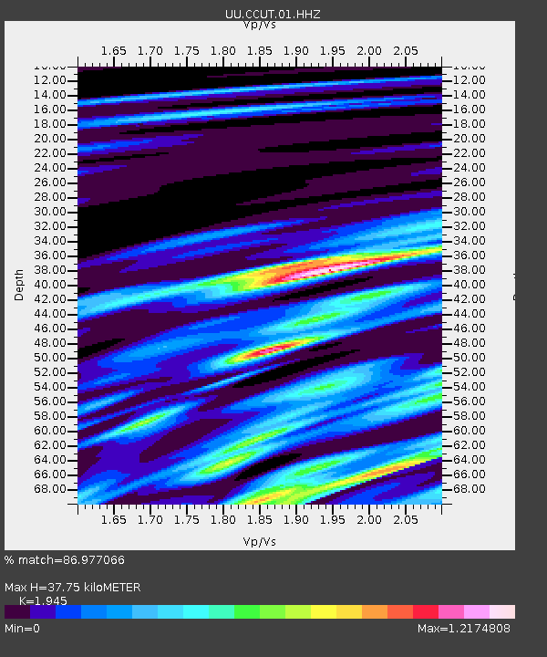
| Estimated Moho Depth: |
37.75 km |
| Estimated Crust Vp/Vs: |
1.95 |
| Assumed Crust Vp: |
6.194 km/s |
| Estimated Crust Vs: |
3.185 km/s |
| Estimated Crust Poisson's Ratio: |
0.32 |
|
| Radial Match: |
86.977066 % |
| Radial Bump: |
400 |
| Transverse Match: |
71.22764 % |
| Transverse Bump: |
400 |
| SOD ConfigId: |
28208852 |
| Insert Time: |
2022-07-26 22:20:11.976 +0000 |
| GWidth: |
2.5 |
| Max Bumps: |
400 |
| Tol: |
0.001 |
|

Signal To Noise
| Channel | StoN | STA | LTA |
| UU:CCUT:01:HHZ:20220712T21:57:30.720005Z | 1.7973362 | 2.4421598E-7 | 1.3587663E-7 |
| UU:CCUT:01:HHN:20220712T21:57:30.720005Z | 1.0604893 | 1.269041E-7 | 1.196656E-7 |
| UU:CCUT:01:HHE:20220712T21:57:30.720005Z | 0.69169563 | 5.757234E-8 | 8.323363E-8 |
| Arrivals |
| Ps | 6.0 SECOND |
| PpPs | 17 SECOND |
| PsPs/PpSs | 23 SECOND |


