You are here: Home > Network List > ET - CERI Southern Appalachian seismic Network Stations List
> Station CPCT Cooper Cave,TN > Earthquake Result Viewer
CPCT Cooper Cave,TN - Earthquake Result Viewer
| Earthquake location: |
Southern Peru |
| Earthquake latitude/longitude: |
-16.8/-71.3 |
| Earthquake time(UTC): |
2022/07/12 (193) 23:36:11 GMT |
| Earthquake Depth: |
10 km |
| Earthquake Magnitude: |
5.5 mww |
| Earthquake Catalog/Contributor: |
NEIC PDE/us |
|
| Network: |
ET CERI Southern Appalachian seismic Network |
| Station: |
CPCT Cooper Cave,TN |
| Lat/Lon: |
35.45 N/84.52 W |
| Elevation: |
275 m |
|
| Distance: |
53.4 deg |
| Az: |
346.566 deg |
| Baz: |
164.183 deg |
| Ray Param: |
0.06611123 |
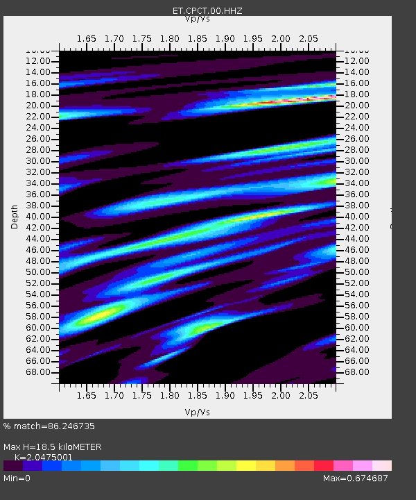
| Estimated Moho Depth: |
18.5 km |
| Estimated Crust Vp/Vs: |
2.05 |
| Assumed Crust Vp: |
6.35 km/s |
| Estimated Crust Vs: |
3.101 km/s |
| Estimated Crust Poisson's Ratio: |
0.34 |
|
| Radial Match: |
86.246735 % |
| Radial Bump: |
400 |
| Transverse Match: |
66.5595 % |
| Transverse Bump: |
400 |
| SOD ConfigId: |
28208852 |
| Insert Time: |
2022-07-26 23:48:17.697 +0000 |
| GWidth: |
2.5 |
| Max Bumps: |
400 |
| Tol: |
0.001 |
|

Signal To Noise
| Channel | StoN | STA | LTA |
| ET:CPCT:00:HHZ:20220712T23:45:00.57002Z | 6.168406 | 5.413321E-7 | 8.775883E-8 |
| ET:CPCT:00:HHN:20220712T23:45:00.57002Z | 5.4406285 | 2.387216E-7 | 4.387758E-8 |
| ET:CPCT:00:HHE:20220712T23:45:00.57002Z | 2.5940268 | 1.3119222E-7 | 5.0574737E-8 |
| Arrivals |
| Ps | 3.2 SECOND |
| PpPs | 8.5 SECOND |
| PsPs/PpSs | 12 SECOND |


