You are here: Home > Network List > GS - US Geological Survey Networks Stations List
> Station MCA04 MCA04, Monte Cristo Range, NV > Earthquake Result Viewer
MCA04 MCA04, Monte Cristo Range, NV - Earthquake Result Viewer
| Earthquake location: |
Southern Peru |
| Earthquake latitude/longitude: |
-16.8/-71.3 |
| Earthquake time(UTC): |
2022/07/12 (193) 23:36:11 GMT |
| Earthquake Depth: |
10 km |
| Earthquake Magnitude: |
5.5 mww |
| Earthquake Catalog/Contributor: |
NEIC PDE/us |
|
| Network: |
GS US Geological Survey Networks |
| Station: |
MCA04 MCA04, Monte Cristo Range, NV |
| Lat/Lon: |
38.08 N/117.71 W |
| Elevation: |
1662 m |
|
| Distance: |
69.8 deg |
| Az: |
322.49 deg |
| Baz: |
132.347 deg |
| Ray Param: |
0.055396803 |
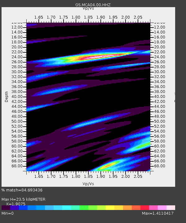
| Estimated Moho Depth: |
23.5 km |
| Estimated Crust Vp/Vs: |
1.91 |
| Assumed Crust Vp: |
6.276 km/s |
| Estimated Crust Vs: |
3.29 km/s |
| Estimated Crust Poisson's Ratio: |
0.31 |
|
| Radial Match: |
84.693436 % |
| Radial Bump: |
400 |
| Transverse Match: |
78.64323 % |
| Transverse Bump: |
400 |
| SOD ConfigId: |
28208852 |
| Insert Time: |
2022-07-26 23:49:40.983 +0000 |
| GWidth: |
2.5 |
| Max Bumps: |
400 |
| Tol: |
0.001 |
|

Signal To Noise
| Channel | StoN | STA | LTA |
| GS:MCA04:00:HHZ:20220712T23:46:50.833997Z | 4.397186 | 4.6341776E-7 | 1.0538963E-7 |
| GS:MCA04:00:HH1:20220712T23:46:50.833997Z | 2.593331 | 1.7370049E-7 | 6.697968E-8 |
| GS:MCA04:00:HH2:20220712T23:46:50.833997Z | 1.7380146 | 1.1180592E-7 | 6.432968E-8 |
| Arrivals |
| Ps | 3.5 SECOND |
| PpPs | 11 SECOND |
| PsPs/PpSs | 14 SECOND |


