You are here: Home > Network List > GS - US Geological Survey Networks Stations List
> Station OK052 Battle Ridge Rd, NW of Cushing, Oklahoma USA > Earthquake Result Viewer
OK052 Battle Ridge Rd, NW of Cushing, Oklahoma USA - Earthquake Result Viewer
| Earthquake location: |
Southern Peru |
| Earthquake latitude/longitude: |
-16.8/-71.3 |
| Earthquake time(UTC): |
2022/07/12 (193) 23:36:11 GMT |
| Earthquake Depth: |
10 km |
| Earthquake Magnitude: |
5.5 mww |
| Earthquake Catalog/Contributor: |
NEIC PDE/us |
|
| Network: |
GS US Geological Survey Networks |
| Station: |
OK052 Battle Ridge Rd, NW of Cushing, Oklahoma USA |
| Lat/Lon: |
36.00 N/96.80 W |
| Elevation: |
261 m |
|
| Distance: |
57.8 deg |
| Az: |
335.634 deg |
| Baz: |
150.834 deg |
| Ray Param: |
0.06327631 |
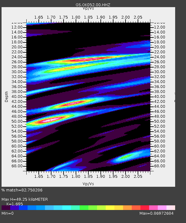
| Estimated Moho Depth: |
49.25 km |
| Estimated Crust Vp/Vs: |
1.70 |
| Assumed Crust Vp: |
6.426 km/s |
| Estimated Crust Vs: |
3.791 km/s |
| Estimated Crust Poisson's Ratio: |
0.23 |
|
| Radial Match: |
82.758286 % |
| Radial Bump: |
400 |
| Transverse Match: |
62.672794 % |
| Transverse Bump: |
400 |
| SOD ConfigId: |
28208852 |
| Insert Time: |
2022-07-26 23:49:44.334 +0000 |
| GWidth: |
2.5 |
| Max Bumps: |
400 |
| Tol: |
0.001 |
|

Signal To Noise
| Channel | StoN | STA | LTA |
| GS:OK052:00:HHZ:20220712T23:45:31.669996Z | 13.261174 | 7.513936E-7 | 5.6661168E-8 |
| GS:OK052:00:HH1:20220712T23:45:31.669996Z | 4.2956777 | 3.3600458E-7 | 7.8219216E-8 |
| GS:OK052:00:HH2:20220712T23:45:31.669996Z | 3.5149627 | 2.9464348E-7 | 8.38255E-8 |
| Arrivals |
| Ps | 5.6 SECOND |
| PpPs | 20 SECOND |
| PsPs/PpSs | 25 SECOND |


