You are here: Home > Network List > BK - Berkeley Digital Seismograph Network Stations List
> Station MCCM Marconi Conference Center, Marshall, CA, USA > Earthquake Result Viewer
MCCM Marconi Conference Center, Marshall, CA, USA - Earthquake Result Viewer
| Earthquake location: |
Fiji Islands Region |
| Earthquake latitude/longitude: |
-17.0/-178.0 |
| Earthquake time(UTC): |
2018/08/19 (231) 04:28:58 GMT |
| Earthquake Depth: |
416 km |
| Earthquake Magnitude: |
6.8 mww |
| Earthquake Catalog/Contributor: |
NEIC PDE/us |
|
| Network: |
BK Berkeley Digital Seismograph Network |
| Station: |
MCCM Marconi Conference Center, Marshall, CA, USA |
| Lat/Lon: |
38.14 N/122.88 W |
| Elevation: |
-7.7 m |
|
| Distance: |
75.4 deg |
| Az: |
41.972 deg |
| Baz: |
234.261 deg |
| Ray Param: |
0.050488804 |
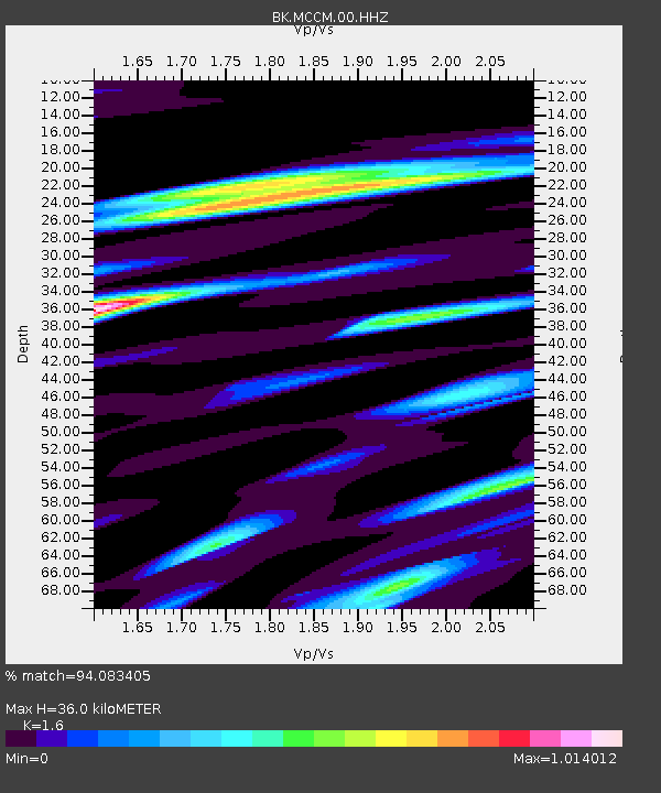
| Estimated Moho Depth: |
36.0 km |
| Estimated Crust Vp/Vs: |
1.60 |
| Assumed Crust Vp: |
6.472 km/s |
| Estimated Crust Vs: |
4.045 km/s |
| Estimated Crust Poisson's Ratio: |
0.18 |
|
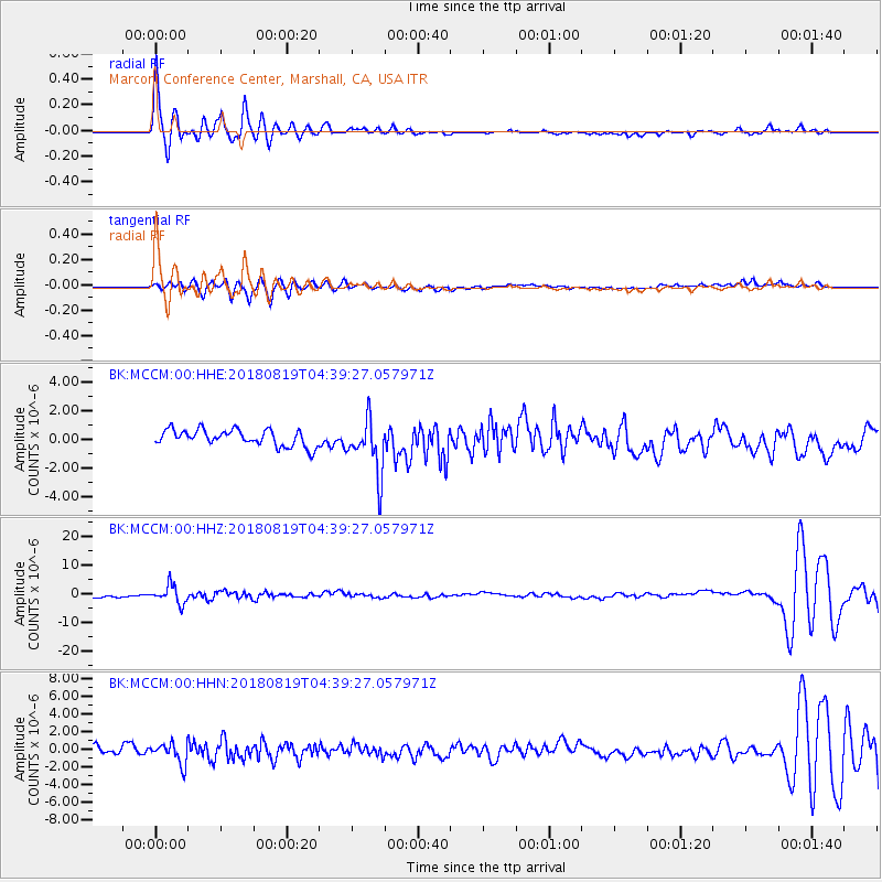
| Radial Match: |
94.083405 % |
| Radial Bump: |
359 |
| Transverse Match: |
80.15286 % |
| Transverse Bump: |
400 |
| SOD ConfigId: |
2825771 |
| Insert Time: |
2018-09-02 04:30:16.520 +0000 |
| GWidth: |
2.5 |
| Max Bumps: |
400 |
| Tol: |
0.001 |
|
Signal To Noise
| Channel | StoN | STA | LTA |
| BK:MCCM:00:HHZ:20180819T04:39:27.057971Z | 6.414788 | 3.1836312E-6 | 4.962956E-7 |
| BK:MCCM:00:HHN:20180819T04:39:27.057971Z | 2.4975715 | 1.1843192E-6 | 4.7418834E-7 |
| BK:MCCM:00:HHE:20180819T04:39:27.057971Z | 3.3531127 | 1.896647E-6 | 5.656377E-7 |
| Arrivals |
| Ps | 3.5 SECOND |
| PpPs | 14 SECOND |
| PsPs/PpSs | 17 SECOND |


