You are here: Home > Network List > O2 - Oklahoma Consolidated Temporary Seismic Networks Stations List
> Station SC18 Garber, Oklahoma, USA > Earthquake Result Viewer
SC18 Garber, Oklahoma, USA - Earthquake Result Viewer
| Earthquake location: |
Southern Peru |
| Earthquake latitude/longitude: |
-16.8/-71.3 |
| Earthquake time(UTC): |
2022/07/12 (193) 23:36:11 GMT |
| Earthquake Depth: |
10 km |
| Earthquake Magnitude: |
5.5 mww |
| Earthquake Catalog/Contributor: |
NEIC PDE/us |
|
| Network: |
O2 Oklahoma Consolidated Temporary Seismic Networks |
| Station: |
SC18 Garber, Oklahoma, USA |
| Lat/Lon: |
36.50 N/97.55 W |
| Elevation: |
1051 m |
|
| Distance: |
58.5 deg |
| Az: |
335.304 deg |
| Baz: |
150.217 deg |
| Ray Param: |
0.06278341 |
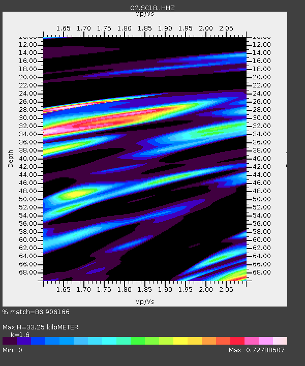
| Estimated Moho Depth: |
33.25 km |
| Estimated Crust Vp/Vs: |
1.60 |
| Assumed Crust Vp: |
6.483 km/s |
| Estimated Crust Vs: |
4.052 km/s |
| Estimated Crust Poisson's Ratio: |
0.18 |
|
| Radial Match: |
86.906166 % |
| Radial Bump: |
400 |
| Transverse Match: |
72.32285 % |
| Transverse Bump: |
400 |
| SOD ConfigId: |
28208852 |
| Insert Time: |
2022-07-26 23:57:47.648 +0000 |
| GWidth: |
2.5 |
| Max Bumps: |
400 |
| Tol: |
0.001 |
|

Signal To Noise
| Channel | StoN | STA | LTA |
| O2:SC18: :HHZ:20220712T23:45:36.834974Z | 10.596495 | 8.18597E-7 | 7.725168E-8 |
| O2:SC18: :HHN:20220712T23:45:36.834974Z | 2.4806008 | 3.50665E-7 | 1.4136293E-7 |
| O2:SC18: :HHE:20220712T23:45:36.834974Z | 1.8734467 | 2.3540743E-7 | 1.2565472E-7 |
| Arrivals |
| Ps | 3.3 SECOND |
| PpPs | 13 SECOND |
| PsPs/PpSs | 16 SECOND |


