You are here: Home > Network List > GS - US Geological Survey Networks Stations List
> Station OK051 E0350 and S34600 Roads, Ralston, OK > Earthquake Result Viewer
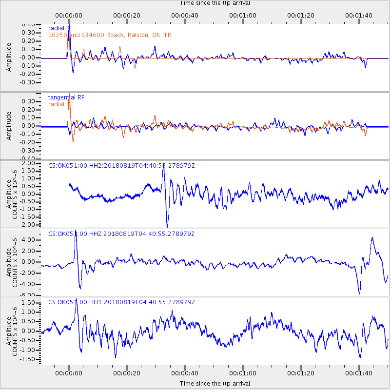
OK051 E0350 and S34600 Roads, Ralston, OK - Earthquake Result Viewer
*The percent match for this event was below the threshold and hence no stack was calculated.
| Earthquake location: |
Fiji Islands Region |
| Earthquake latitude/longitude: |
-17.0/-178.0 |
| Earthquake time(UTC): |
2018/08/19 (231) 04:28:58 GMT |
| Earthquake Depth: |
416 km |
| Earthquake Magnitude: |
6.8 mww |
| Earthquake Catalog/Contributor: |
NEIC PDE/us |
|
| Network: |
GS US Geological Survey Networks |
| Station: |
OK051 E0350 and S34600 Roads, Ralston, OK |
| Lat/Lon: |
36.51 N/96.84 W |
| Elevation: |
263 m |
|
| Distance: |
93.1 deg |
| Az: |
52.88 deg |
| Baz: |
251.274 deg |
| Ray Param: |
$rayparam |
*The percent match for this event was below the threshold and hence was not used in the summary stack. |
|
| Radial Match: |
62.655323 % |
| Radial Bump: |
290 |
| Transverse Match: |
44.19367 % |
| Transverse Bump: |
290 |
| SOD ConfigId: |
2825771 |
| Insert Time: |
2018-09-02 04:31:27.072 +0000 |
| GWidth: |
2.5 |
| Max Bumps: |
400 |
| Tol: |
0.001 |
|
Signal To Noise
| Channel | StoN | STA | LTA |
| GS:OK051:00:HHZ:20180819T04:40:55.278979Z | 4.6523128 | 2.5194813E-6 | 5.4155464E-7 |
| GS:OK051:00:HH1:20180819T04:40:55.278979Z | 2.3202055 | 9.3511676E-7 | 4.030319E-7 |
| GS:OK051:00:HH2:20180819T04:40:55.278979Z | 4.178378 | 1.0171063E-6 | 2.434213E-7 |
| Arrivals |
| Ps | |
| PpPs | |
| PsPs/PpSs | |


