You are here: Home > Network List > TX - Texas Seismological Network Stations List
> Station PLPT Palo Pinto > Earthquake Result Viewer
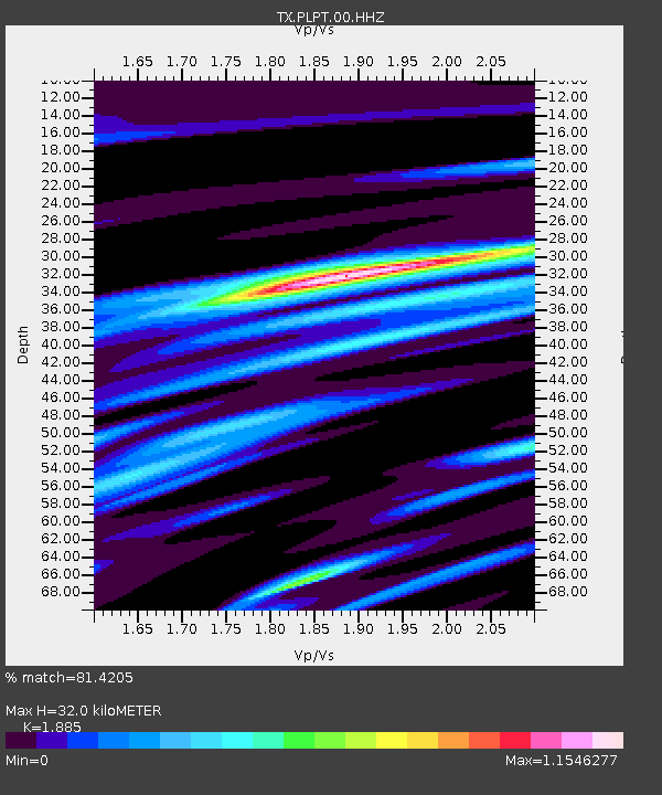
PLPT Palo Pinto - Earthquake Result Viewer
| Earthquake location: |
Southern Peru |
| Earthquake latitude/longitude: |
-16.8/-71.3 |
| Earthquake time(UTC): |
2022/07/12 (193) 23:36:11 GMT |
| Earthquake Depth: |
10 km |
| Earthquake Magnitude: |
5.5 mww |
| Earthquake Catalog/Contributor: |
NEIC PDE/us |
|
| Network: |
TX Texas Seismological Network |
| Station: |
PLPT Palo Pinto |
| Lat/Lon: |
32.81 N/98.32 W |
| Elevation: |
336 m |
|
| Distance: |
55.7 deg |
| Az: |
332.418 deg |
| Baz: |
148.217 deg |
| Ray Param: |
0.06464246 |
| Estimated Moho Depth: |
32.0 km |
| Estimated Crust Vp/Vs: |
1.88 |
| Assumed Crust Vp: |
6.426 km/s |
| Estimated Crust Vs: |
3.409 km/s |
| Estimated Crust Poisson's Ratio: |
0.30 |
|
| Radial Match: |
81.4205 % |
| Radial Bump: |
400 |
| Transverse Match: |
65.890854 % |
| Transverse Bump: |
400 |
| SOD ConfigId: |
28208852 |
| Insert Time: |
2022-07-27 00:02:31.532 +0000 |
| GWidth: |
2.5 |
| Max Bumps: |
400 |
| Tol: |
0.001 |
|

Signal To Noise
| Channel | StoN | STA | LTA |
| TX:PLPT:00:HHZ:20220712T23:45:16.765027Z | 7.2348 | 5.0525557E-7 | 6.9836844E-8 |
| TX:PLPT:00:HH1:20220712T23:45:16.765027Z | 3.869247 | 1.7024915E-7 | 4.400059E-8 |
| TX:PLPT:00:HH2:20220712T23:45:16.765027Z | 4.527093 | 2.4822543E-7 | 5.4831084E-8 |
| Arrivals |
| Ps | 4.6 SECOND |
| PpPs | 14 SECOND |
| PsPs/PpSs | 18 SECOND |


