You are here: Home > Network List > PR - Puerto Rico Seismic Network (PRSN) & Puerto Rico Strong Motion Program (PRSMP) Stations List
> Station AOPR Arecibo, Puerto Rico (T3D36) > Earthquake Result Viewer
AOPR Arecibo, Puerto Rico (T3D36) - Earthquake Result Viewer
| Earthquake location: |
Chile-Bolivia Border Region |
| Earthquake latitude/longitude: |
-22.3/-67.9 |
| Earthquake time(UTC): |
2005/11/17 (321) 19:26:56 GMT |
| Earthquake Depth: |
163 km |
| Earthquake Magnitude: |
6.0 MB, 6.9 MW, 6.8 MW |
| Earthquake Catalog/Contributor: |
WHDF/NEIC |
|
| Network: |
PR Puerto Rico Seismic Network (PRSN) & Puerto Rico Strong Motion Program (PRSMP) |
| Station: |
AOPR Arecibo, Puerto Rico (T3D36) |
| Lat/Lon: |
18.35 N/66.75 W |
| Elevation: |
355 m |
|
| Distance: |
40.4 deg |
| Az: |
1.659 deg |
| Baz: |
181.618 deg |
| Ray Param: |
0.07379472 |
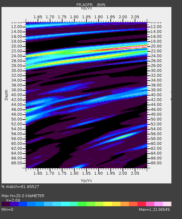
| Estimated Moho Depth: |
20.0 km |
| Estimated Crust Vp/Vs: |
2.08 |
| Assumed Crust Vp: |
5.14 km/s |
| Estimated Crust Vs: |
2.471 km/s |
| Estimated Crust Poisson's Ratio: |
0.35 |
|
| Radial Match: |
81.65527 % |
| Radial Bump: |
400 |
| Transverse Match: |
51.735863 % |
| Transverse Bump: |
400 |
| SOD ConfigId: |
2422 |
| Insert Time: |
2010-03-09 22:28:52.705 +0000 |
| GWidth: |
2.5 |
| Max Bumps: |
400 |
| Tol: |
0.001 |
|

Signal To Noise
| Channel | StoN | STA | LTA |
| PR:AOPR: :BHN:20051117T19:33:48.36399Z | 4.6780252 | 3.1938268E-6 | 6.827297E-7 |
| PR:AOPR: :BHE:20051117T19:33:48.36399Z | 3.7650337 | 3.487105E-6 | 9.2618166E-7 |
| PR:AOPR: :BHZ:20051117T19:33:48.36399Z | 11.991181 | 8.838894E-6 | 7.3711624E-7 |
| Arrivals |
| Ps | 4.4 SECOND |
| PpPs | 12 SECOND |
| PsPs/PpSs | 16 SECOND |


