You are here: Home > Network List > XM99 - Rio Grande Seismic Transect Stations List
> Station NM23 NewMexico23 > Earthquake Result Viewer
NM23 NewMexico23 - Earthquake Result Viewer
| Earthquake location: |
Kermadec Islands Region |
| Earthquake latitude/longitude: |
-31.3/179.8 |
| Earthquake time(UTC): |
2000/05/08 (129) 21:35:42 GMT |
| Earthquake Depth: |
383 km |
| Earthquake Magnitude: |
5.4 MB, 5.7 MW, 5.6 MW |
| Earthquake Catalog/Contributor: |
WHDF/NEIC |
|
| Network: |
XM Rio Grande Seismic Transect |
| Station: |
NM23 NewMexico23 |
| Lat/Lon: |
33.95 N/106.01 W |
| Elevation: |
1813 m |
|
| Distance: |
95.3 deg |
| Az: |
53.431 deg |
| Baz: |
235.78 deg |
| Ray Param: |
0.040460978 |
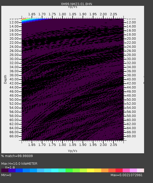
| Estimated Moho Depth: |
10.0 km |
| Estimated Crust Vp/Vs: |
1.60 |
| Assumed Crust Vp: |
6.502 km/s |
| Estimated Crust Vs: |
4.063 km/s |
| Estimated Crust Poisson's Ratio: |
0.18 |
|
| Radial Match: |
99.99889 % |
| Radial Bump: |
2 |
| Transverse Match: |
99.996414 % |
| Transverse Bump: |
2 |
| SOD ConfigId: |
16820 |
| Insert Time: |
2010-02-26 17:34:20.205 +0000 |
| GWidth: |
2.5 |
| Max Bumps: |
400 |
| Tol: |
0.001 |
|
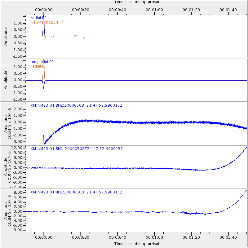
Signal To Noise
| Channel | StoN | STA | LTA |
| XM:NM23:01:BHN:20000508T21:47:52.990015Z | 0.90400666 | 9.753215E-7 | 1.0788875E-6 |
| XM:NM23:01:BHE:20000508T21:47:52.990015Z | 1.0442941 | 6.9416177E-7 | 6.6471864E-7 |
| XM:NM23:01:BHZ:20000508T21:47:52.990015Z | 0.9044138 | 9.786366E-7 | 1.0820673E-6 |
| Arrivals |
| Ps | 0.9 SECOND |
| PpPs | 3.9 SECOND |
| PsPs/PpSs | 4.9 SECOND |


