You are here: Home > Network List > IU - Global Seismograph Network (GSN - IRIS/USGS) Stations List
> Station PAYG Puerto Ayora, Galapagos Islands > Earthquake Result Viewer
PAYG Puerto Ayora, Galapagos Islands - Earthquake Result Viewer
| Earthquake location: |
Fiji Islands Region |
| Earthquake latitude/longitude: |
-17.0/-178.0 |
| Earthquake time(UTC): |
2018/08/19 (231) 04:28:58 GMT |
| Earthquake Depth: |
416 km |
| Earthquake Magnitude: |
6.8 mww |
| Earthquake Catalog/Contributor: |
NEIC PDE/us |
|
| Network: |
IU Global Seismograph Network (GSN - IRIS/USGS) |
| Station: |
PAYG Puerto Ayora, Galapagos Islands |
| Lat/Lon: |
0.67 S/90.29 W |
| Elevation: |
270 m |
|
| Distance: |
87.6 deg |
| Az: |
89.987 deg |
| Baz: |
253.142 deg |
| Ray Param: |
0.04208346 |
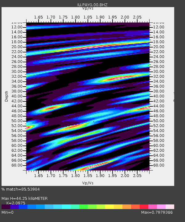
| Estimated Moho Depth: |
44.25 km |
| Estimated Crust Vp/Vs: |
2.10 |
| Assumed Crust Vp: |
4.802 km/s |
| Estimated Crust Vs: |
2.289 km/s |
| Estimated Crust Poisson's Ratio: |
0.35 |
|
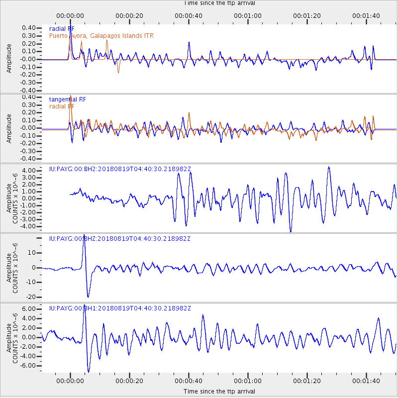
| Radial Match: |
85.53984 % |
| Radial Bump: |
400 |
| Transverse Match: |
80.700096 % |
| Transverse Bump: |
338 |
| SOD ConfigId: |
2825771 |
| Insert Time: |
2018-09-02 04:32:10.699 +0000 |
| GWidth: |
2.5 |
| Max Bumps: |
400 |
| Tol: |
0.001 |
|
Signal To Noise
| Channel | StoN | STA | LTA |
| IU:PAYG:00:BHZ:20180819T04:40:30.218982Z | 12.565436 | 6.926821E-6 | 5.5125986E-7 |
| IU:PAYG:00:BH1:20180819T04:40:30.218982Z | 2.3657057 | 1.9843708E-6 | 8.3880707E-7 |
| IU:PAYG:00:BH2:20180819T04:40:30.218982Z | 0.7384464 | 4.2204366E-7 | 5.7152914E-7 |
| Arrivals |
| Ps | 10 SECOND |
| PpPs | 28 SECOND |
| PsPs/PpSs | 38 SECOND |


