You are here: Home > Network List > UW - Pacific Northwest Regional Seismic Network Stations List
> Station UMAT Pilot Rock, OR, USA > Earthquake Result Viewer
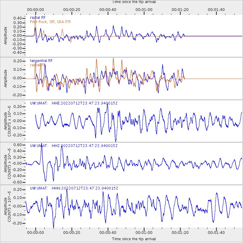
UMAT Pilot Rock, OR, USA - Earthquake Result Viewer
*The percent match for this event was below the threshold and hence no stack was calculated.
| Earthquake location: |
Southern Peru |
| Earthquake latitude/longitude: |
-16.8/-71.3 |
| Earthquake time(UTC): |
2022/07/12 (193) 23:36:11 GMT |
| Earthquake Depth: |
10 km |
| Earthquake Magnitude: |
5.5 mww |
| Earthquake Catalog/Contributor: |
NEIC PDE/us |
|
| Network: |
UW Pacific Northwest Regional Seismic Network |
| Station: |
UMAT Pilot Rock, OR, USA |
| Lat/Lon: |
45.29 N/118.96 W |
| Elevation: |
1318 m |
|
| Distance: |
75.4 deg |
| Az: |
327.377 deg |
| Baz: |
132.98 deg |
| Ray Param: |
$rayparam |
*The percent match for this event was below the threshold and hence was not used in the summary stack. |
|
| Radial Match: |
59.593174 % |
| Radial Bump: |
400 |
| Transverse Match: |
65.03387 % |
| Transverse Bump: |
400 |
| SOD ConfigId: |
28208852 |
| Insert Time: |
2022-07-27 00:06:37.425 +0000 |
| GWidth: |
2.5 |
| Max Bumps: |
400 |
| Tol: |
0.001 |
|
Signal To Noise
| Channel | StoN | STA | LTA |
| UW:UMAT: :HHZ:20220712T23:47:23.940015Z | 2.3627737 | 2.2385666E-7 | 9.4743164E-8 |
| UW:UMAT: :HHN:20220712T23:47:23.940015Z | 0.85819995 | 5.250623E-8 | 6.1181815E-8 |
| UW:UMAT: :HHE:20220712T23:47:23.940015Z | 1.6135172 | 9.7367916E-8 | 6.034514E-8 |
| Arrivals |
| Ps | |
| PpPs | |
| PsPs/PpSs | |


