You are here: Home > Network List > IW - Intermountain West Stations List
> Station IMW Indian Meadow, Wyoming, USA > Earthquake Result Viewer
IMW Indian Meadow, Wyoming, USA - Earthquake Result Viewer
| Earthquake location: |
Fiji Islands Region |
| Earthquake latitude/longitude: |
-17.0/-178.0 |
| Earthquake time(UTC): |
2018/08/19 (231) 04:28:58 GMT |
| Earthquake Depth: |
416 km |
| Earthquake Magnitude: |
6.8 mww |
| Earthquake Catalog/Contributor: |
NEIC PDE/us |
|
| Network: |
IW Intermountain West |
| Station: |
IMW Indian Meadow, Wyoming, USA |
| Lat/Lon: |
43.90 N/110.94 W |
| Elevation: |
2646 m |
|
| Distance: |
86.1 deg |
| Az: |
41.873 deg |
| Baz: |
242.078 deg |
| Ray Param: |
0.04322944 |
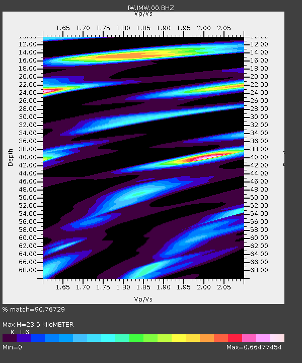
| Estimated Moho Depth: |
23.5 km |
| Estimated Crust Vp/Vs: |
1.60 |
| Assumed Crust Vp: |
6.207 km/s |
| Estimated Crust Vs: |
3.879 km/s |
| Estimated Crust Poisson's Ratio: |
0.18 |
|
| Radial Match: |
90.76729 % |
| Radial Bump: |
327 |
| Transverse Match: |
57.298668 % |
| Transverse Bump: |
400 |
| SOD ConfigId: |
2825771 |
| Insert Time: |
2018-09-02 04:32:42.724 +0000 |
| GWidth: |
2.5 |
| Max Bumps: |
400 |
| Tol: |
0.001 |
|
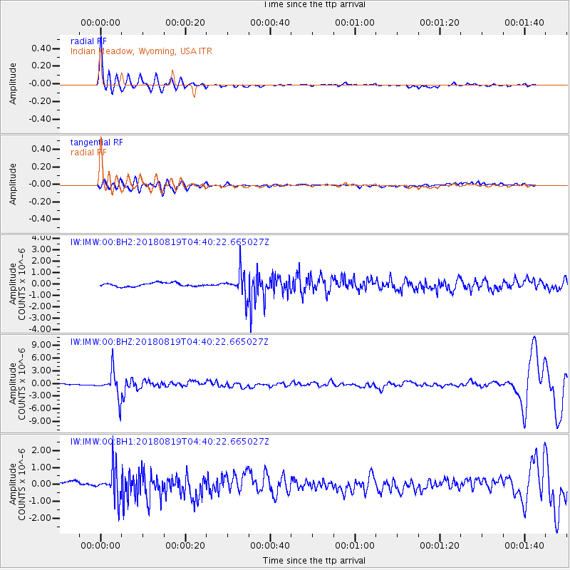
Signal To Noise
| Channel | StoN | STA | LTA |
| IW:IMW:00:BHZ:20180819T04:40:22.665027Z | 12.516362 | 3.18935E-6 | 2.5481447E-7 |
| IW:IMW:00:BH1:20180819T04:40:22.665027Z | 7.5156465 | 8.9445814E-7 | 1.19012796E-7 |
| IW:IMW:00:BH2:20180819T04:40:22.665027Z | 7.133297 | 1.1151794E-6 | 1.5633437E-7 |
| Arrivals |
| Ps | 2.3 SECOND |
| PpPs | 9.6 SECOND |
| PsPs/PpSs | 12 SECOND |


