You are here: Home > Network List > TA - USArray Transportable Network (new EarthScope stations) Stations List
> Station POKR Poker Plat Research Range, AK, USA > Earthquake Result Viewer
POKR Poker Plat Research Range, AK, USA - Earthquake Result Viewer
| Earthquake location: |
Fiji Islands Region |
| Earthquake latitude/longitude: |
-17.0/-178.0 |
| Earthquake time(UTC): |
2018/08/19 (231) 04:28:58 GMT |
| Earthquake Depth: |
416 km |
| Earthquake Magnitude: |
6.8 mww |
| Earthquake Catalog/Contributor: |
NEIC PDE/us |
|
| Network: |
TA USArray Transportable Network (new EarthScope stations) |
| Station: |
POKR Poker Plat Research Range, AK, USA |
| Lat/Lon: |
65.12 N/147.43 W |
| Elevation: |
501 m |
|
| Distance: |
85.1 deg |
| Az: |
12.484 deg |
| Baz: |
209.27 deg |
| Ray Param: |
0.043908447 |
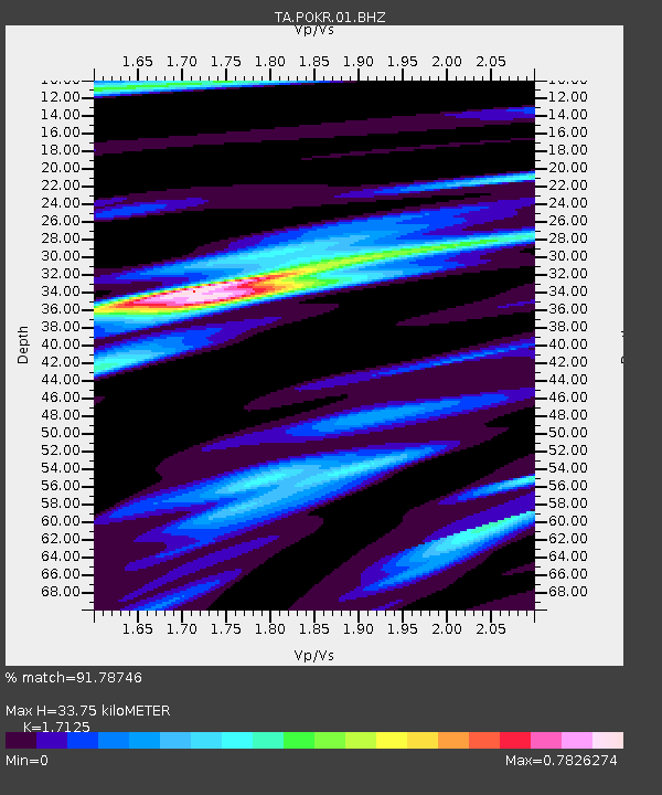
| Estimated Moho Depth: |
33.75 km |
| Estimated Crust Vp/Vs: |
1.71 |
| Assumed Crust Vp: |
6.566 km/s |
| Estimated Crust Vs: |
3.834 km/s |
| Estimated Crust Poisson's Ratio: |
0.24 |
|
| Radial Match: |
91.78746 % |
| Radial Bump: |
322 |
| Transverse Match: |
67.256645 % |
| Transverse Bump: |
400 |
| SOD ConfigId: |
2825771 |
| Insert Time: |
2018-09-02 04:33:12.592 +0000 |
| GWidth: |
2.5 |
| Max Bumps: |
400 |
| Tol: |
0.001 |
|

Signal To Noise
| Channel | StoN | STA | LTA |
| TA:POKR:01:BHZ:20180819T04:40:18.025012Z | 4.7927995 | 2.4243195E-6 | 5.058253E-7 |
| TA:POKR:01:BHN:20180819T04:40:18.025012Z | 4.9302883 | 1.0288531E-6 | 2.0868012E-7 |
| TA:POKR:01:BHE:20180819T04:40:18.025012Z | 1.4366903 | 7.508619E-7 | 5.2263306E-7 |
| Arrivals |
| Ps | 3.8 SECOND |
| PpPs | 14 SECOND |
| PsPs/PpSs | 17 SECOND |


