You are here: Home > Network List > AG - Arkansas Seismic Network Stations List
> Station HHAR Hobbs,AR > Earthquake Result Viewer
HHAR Hobbs,AR - Earthquake Result Viewer
| Earthquake location: |
Near Coast Of Venezuela |
| Earthquake latitude/longitude: |
10.7/-62.6 |
| Earthquake time(UTC): |
2022/07/14 (195) 19:16:59 GMT |
| Earthquake Depth: |
111 km |
| Earthquake Magnitude: |
5.5 mb |
| Earthquake Catalog/Contributor: |
NEIC PDE/us |
|
| Network: |
AG Arkansas Seismic Network |
| Station: |
HHAR Hobbs,AR |
| Lat/Lon: |
36.28 N/93.94 W |
| Elevation: |
421 m |
|
| Distance: |
38.1 deg |
| Az: |
317.079 deg |
| Baz: |
124.074 deg |
| Ray Param: |
0.07541661 |
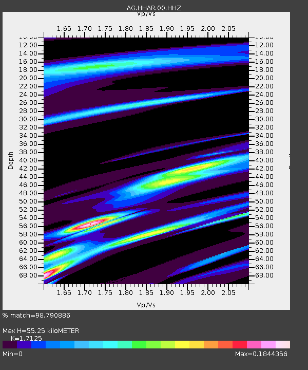
| Estimated Moho Depth: |
55.25 km |
| Estimated Crust Vp/Vs: |
1.71 |
| Assumed Crust Vp: |
6.53 km/s |
| Estimated Crust Vs: |
3.813 km/s |
| Estimated Crust Poisson's Ratio: |
0.24 |
|
| Radial Match: |
98.790886 % |
| Radial Bump: |
89 |
| Transverse Match: |
98.25552 % |
| Transverse Bump: |
135 |
| SOD ConfigId: |
28208852 |
| Insert Time: |
2022-07-28 19:19:35.680 +0000 |
| GWidth: |
2.5 |
| Max Bumps: |
400 |
| Tol: |
0.001 |
|

Signal To Noise
| Channel | StoN | STA | LTA |
| AG:HHAR:00:HHZ:20220714T19:23:36.649987Z | 2.7070947 | 4.5084835E-6 | 1.6654325E-6 |
| AG:HHAR:00:HHN:20220714T19:23:36.649987Z | 2.5520737 | 5.353208E-6 | 2.0975915E-6 |
| AG:HHAR:00:HHE:20220714T19:23:36.649987Z | 1.5085764 | 2.4304095E-6 | 1.6110616E-6 |
| Arrivals |
| Ps | 6.5 SECOND |
| PpPs | 21 SECOND |
| PsPs/PpSs | 28 SECOND |


