You are here: Home > Network List > PR - Puerto Rico Seismic Network (PRSN) & Puerto Rico Strong Motion Program (PRSMP) Stations List
> Station CRPR Cabo Rojo, Puerto Rico(T3K97) > Earthquake Result Viewer
CRPR Cabo Rojo, Puerto Rico(T3K97) - Earthquake Result Viewer
| Earthquake location: |
Norwegian Sea |
| Earthquake latitude/longitude: |
72.2/0.9 |
| Earthquake time(UTC): |
2009/08/20 (232) 06:35:04 GMT |
| Earthquake Depth: |
6.0 km |
| Earthquake Magnitude: |
5.9 MB, 5.7 MS, 6.0 MW, 6.0 MW |
| Earthquake Catalog/Contributor: |
WHDF/NEIC |
|
| Network: |
PR Puerto Rico Seismic Network (PRSN) & Puerto Rico Strong Motion Program (PRSMP) |
| Station: |
CRPR Cabo Rojo, Puerto Rico(T3K97) |
| Lat/Lon: |
18.01 N/67.11 W |
| Elevation: |
65 m |
|
| Distance: |
66.3 deg |
| Az: |
254.552 deg |
| Baz: |
18.151 deg |
| Ray Param: |
0.057706725 |
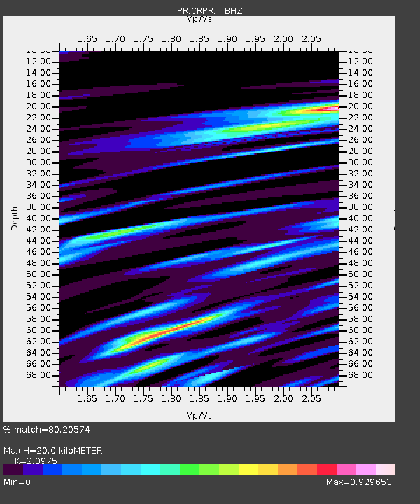
| Estimated Moho Depth: |
20.0 km |
| Estimated Crust Vp/Vs: |
2.10 |
| Assumed Crust Vp: |
5.14 km/s |
| Estimated Crust Vs: |
2.451 km/s |
| Estimated Crust Poisson's Ratio: |
0.35 |
|
| Radial Match: |
80.20574 % |
| Radial Bump: |
400 |
| Transverse Match: |
78.84503 % |
| Transverse Bump: |
400 |
| SOD ConfigId: |
2622 |
| Insert Time: |
2010-03-09 22:31:15.879 +0000 |
| GWidth: |
2.5 |
| Max Bumps: |
400 |
| Tol: |
0.001 |
|

Signal To Noise
| Channel | StoN | STA | LTA |
| PR:CRPR: :BHZ:20090820T06:45:22.443Z | 7.704173 | 1.8735823E-6 | 2.4319058E-7 |
| PR:CRPR: :BHN:20090820T06:45:22.443Z | 2.6601815 | 7.8063346E-7 | 2.934512E-7 |
| PR:CRPR: :BHE:20090820T06:45:22.443Z | 1.5514376 | 3.783001E-7 | 2.4383843E-7 |
| Arrivals |
| Ps | 4.4 SECOND |
| PpPs | 12 SECOND |
| PsPs/PpSs | 16 SECOND |


