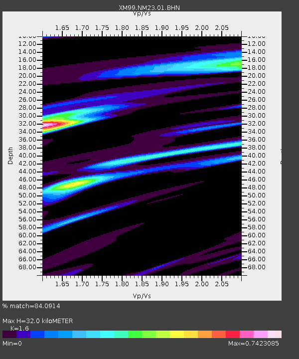
NM23 NewMexico23 - Earthquake Result Viewer
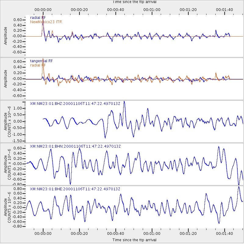
Earthquake location: Kodiak Island Region, Alaska
Earthquake latitude/longitude: 56.2/-153.5
Earthquake time(UTC): 2000/11/06 (311) 11:40:26 GMT
Earthquake Depth: 20 km
Earthquake Magnitude: 5.5 MB, 5.6 MS, 6.0 MW, 5.5 ML
Earthquake Catalog/Contributor: WHDF/NEIC
Network: XM Rio Grande Seismic Transect
Station: NM23 NewMexico23
Lat/Lon: 33.95 N/106.01 W
Elevation: 1813 m
Distance: 39.2 deg
Az: 104.192 deg
Baz: 319.258 deg
Ray Param: 0.07511534
Estimated Moho Depth: 32.0 km
Estimated Crust Vp/Vs: 1.60
Assumed Crust Vp: 6.502 km/s
Estimated Crust Vs: 4.063 km/s
Estimated Crust Poisson's Ratio: 0.18
Radial Match: 84.0914 %
Radial Bump: 400
Transverse Match: 58.08782 %
Transverse Bump: 400
SOD ConfigId: 16820
Insert Time: 2010-02-26 17:34:31.990 +0000
GWidth: 2.5
Max Bumps: 400
Tol: 0.001

Signal To Noise

ChannelStoNSTALTA
XM:NM23:01:BHN:20001106T11:47:22.497013Z2.09408432.86383E-71.3675812E-7
XM:NM23:01:BHE:20001106T11:47:22.497013Z1.64973632.259027E-71.3693261E-7
XM:NM23:01:BHZ:20001106T11:47:22.497013Z2.30475194.901877E-72.1268568E-7
Arrivals
Ps3.2 SECOND
PpPs12 SECOND
PsPs/PpSs15 SECOND