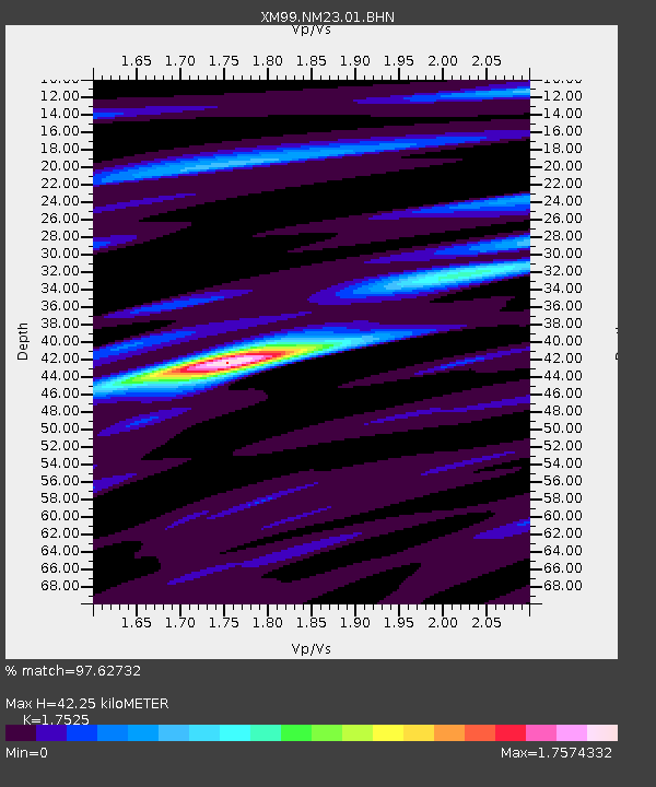
NM23 NewMexico23 - Earthquake Result Viewer
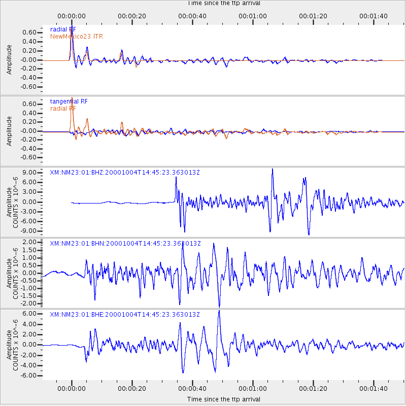
Earthquake location: Windward Islands
Earthquake latitude/longitude: 11.1/-62.6
Earthquake time(UTC): 2000/10/04 (278) 14:37:44 GMT
Earthquake Depth: 110 km
Earthquake Magnitude: 5.6 MB, 5.4 MS, 6.1 MW, 5.9 MD
Earthquake Catalog/Contributor: WHDF/NEIC
Network: XM Rio Grande Seismic Transect
Station: NM23 NewMexico23
Lat/Lon: 33.95 N/106.01 W
Elevation: 1813 m
Distance: 45.7 deg
Az: 306.942 deg
Baz: 109.325 deg
Ray Param: 0.07075299
Estimated Moho Depth: 42.25 km
Estimated Crust Vp/Vs: 1.75
Assumed Crust Vp: 6.502 km/s
Estimated Crust Vs: 3.71 km/s
Estimated Crust Poisson's Ratio: 0.26
Radial Match: 97.62732 %
Radial Bump: 351
Transverse Match: 91.697205 %
Transverse Bump: 400
SOD ConfigId: 16820
Insert Time: 2010-02-26 17:34:34.159 +0000
GWidth: 2.5
Max Bumps: 400
Tol: 0.001

Signal To Noise

ChannelStoNSTALTA
XM:NM23:01:BHN:20001004T14:45:23.363013Z1.82566892.2000272E-71.2050526E-7
XM:NM23:01:BHE:20001004T14:45:23.363013Z5.179727.909274E-71.5269696E-7
XM:NM23:01:BHZ:20001004T14:45:23.363013Z12.525591.9287802E-61.5398719E-7
Arrivals
Ps5.2 SECOND
PpPs17 SECOND
PsPs/PpSs22 SECOND