You are here: Home > Network List > XM99 - Rio Grande Seismic Transect Stations List
> Station NM23 NewMexico23 > Earthquake Result Viewer
NM23 NewMexico23 - Earthquake Result Viewer
| Earthquake location: |
Tonga Islands |
| Earthquake latitude/longitude: |
-15.9/-173.7 |
| Earthquake time(UTC): |
2000/09/11 (255) 17:17:53 GMT |
| Earthquake Depth: |
115 km |
| Earthquake Magnitude: |
6.0 MB, 6.3 MW, 6.3 MW |
| Earthquake Catalog/Contributor: |
WHDF/NEIC |
|
| Network: |
XM Rio Grande Seismic Transect |
| Station: |
NM23 NewMexico23 |
| Lat/Lon: |
33.95 N/106.01 W |
| Elevation: |
1813 m |
|
| Distance: |
81.2 deg |
| Az: |
51.086 deg |
| Baz: |
244.261 deg |
| Ray Param: |
0.04747689 |
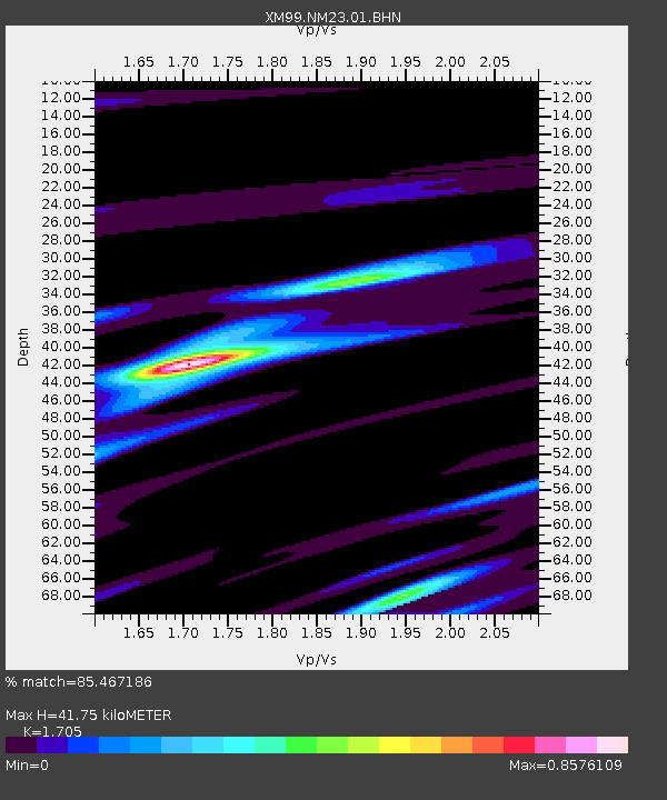
| Estimated Moho Depth: |
41.75 km |
| Estimated Crust Vp/Vs: |
1.71 |
| Assumed Crust Vp: |
6.502 km/s |
| Estimated Crust Vs: |
3.813 km/s |
| Estimated Crust Poisson's Ratio: |
0.24 |
|
| Radial Match: |
85.467186 % |
| Radial Bump: |
400 |
| Transverse Match: |
81.82086 % |
| Transverse Bump: |
400 |
| SOD ConfigId: |
16820 |
| Insert Time: |
2010-02-26 17:34:38.293 +0000 |
| GWidth: |
2.5 |
| Max Bumps: |
400 |
| Tol: |
0.001 |
|
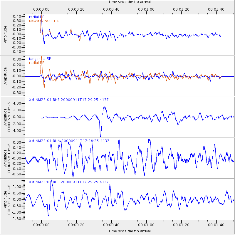
Signal To Noise
| Channel | StoN | STA | LTA |
| XM:NM23:01:BHN:20000911T17:29:25.413Z | 1.1577342 | 1.5849862E-7 | 1.3690416E-7 |
| XM:NM23:01:BHE:20000911T17:29:25.413Z | 2.975876 | 5.737605E-7 | 1.9280388E-7 |
| XM:NM23:01:BHZ:20000911T17:29:25.413Z | 7.1697593 | 2.0886246E-6 | 2.913103E-7 |
| Arrivals |
| Ps | 4.7 SECOND |
| PpPs | 17 SECOND |
| PsPs/PpSs | 22 SECOND |


