You are here: Home > Network List > C0 - Colorado Geological Survey Seismic Network Stations List
> Station LAMA Lamar Colorado > Earthquake Result Viewer
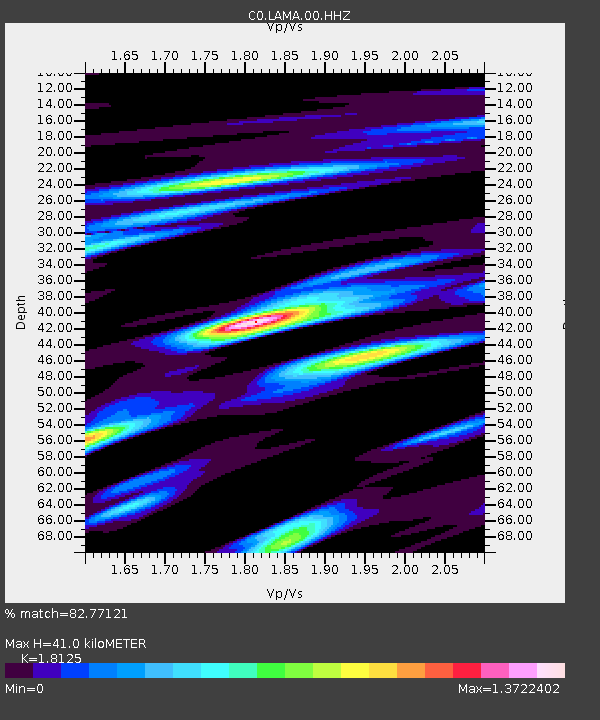
LAMA Lamar Colorado - Earthquake Result Viewer
| Earthquake location: |
Near Coast Of Ecuador |
| Earthquake latitude/longitude: |
-2.1/-79.8 |
| Earthquake time(UTC): |
2022/07/14 (195) 22:30:13 GMT |
| Earthquake Depth: |
81 km |
| Earthquake Magnitude: |
5.7 mww |
| Earthquake Catalog/Contributor: |
NEIC PDE/us |
|
| Network: |
C0 Colorado Geological Survey Seismic Network |
| Station: |
LAMA Lamar Colorado |
| Lat/Lon: |
38.27 N/102.65 W |
| Elevation: |
1182 m |
|
| Distance: |
45.4 deg |
| Az: |
334.536 deg |
| Baz: |
146.913 deg |
| Ray Param: |
0.07106931 |
| Estimated Moho Depth: |
41.0 km |
| Estimated Crust Vp/Vs: |
1.81 |
| Assumed Crust Vp: |
6.242 km/s |
| Estimated Crust Vs: |
3.444 km/s |
| Estimated Crust Poisson's Ratio: |
0.28 |
|
| Radial Match: |
82.77121 % |
| Radial Bump: |
400 |
| Transverse Match: |
72.08511 % |
| Transverse Bump: |
400 |
| SOD ConfigId: |
28208852 |
| Insert Time: |
2022-07-28 22:46:08.597 +0000 |
| GWidth: |
2.5 |
| Max Bumps: |
400 |
| Tol: |
0.001 |
|

Signal To Noise
| Channel | StoN | STA | LTA |
| C0:LAMA:00:HHZ:20220714T22:37:52.819011Z | 9.918227 | 1.0919131E-6 | 1.10091555E-7 |
| C0:LAMA:00:HHN:20220714T22:37:52.819011Z | 7.00936 | 4.4579085E-7 | 6.359937E-8 |
| C0:LAMA:00:HHE:20220714T22:37:52.819011Z | 2.21245 | 2.7712628E-7 | 1.2525766E-7 |
| Arrivals |
| Ps | 5.7 SECOND |
| PpPs | 17 SECOND |
| PsPs/PpSs | 23 SECOND |


