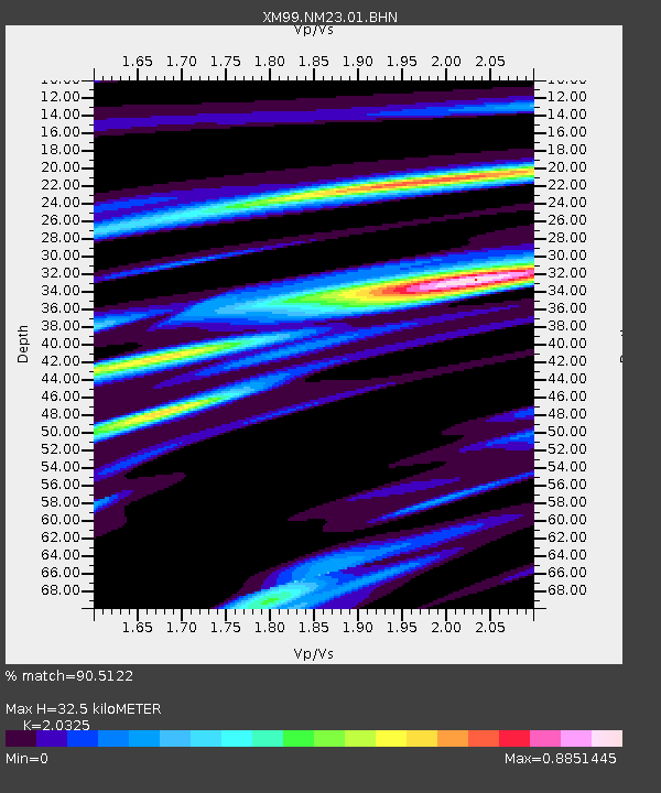
NM23 NewMexico23 - Earthquake Result Viewer
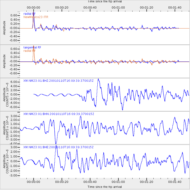
Earthquake location: Kodiak Island Region, Alaska
Earthquake latitude/longitude: 57.1/-153.2
Earthquake time(UTC): 2001/01/10 (010) 16:02:44 GMT
Earthquake Depth: 33 km
Earthquake Magnitude: 6.2 MB, 6.8 MS, 7.1 MW, 6.8 ML
Earthquake Catalog/Contributor: WHDF/NEIC
Network: XM Rio Grande Seismic Transect
Station: NM23 NewMexico23
Lat/Lon: 33.95 N/106.01 W
Elevation: 1813 m
Distance: 39.3 deg
Az: 105.54 deg
Baz: 320.735 deg
Ray Param: 0.07501503
Estimated Moho Depth: 32.5 km
Estimated Crust Vp/Vs: 2.03
Assumed Crust Vp: 6.502 km/s
Estimated Crust Vs: 3.199 km/s
Estimated Crust Poisson's Ratio: 0.34
Radial Match: 90.5122 %
Radial Bump: 395
Transverse Match: 76.71609 %
Transverse Bump: 400
SOD ConfigId: 16820
Insert Time: 2010-02-26 17:34:41.963 +0000
GWidth: 2.5
Max Bumps: 400
Tol: 0.001

Signal To Noise

ChannelStoNSTALTA
XM:NM23:01:BHN:20010110T16:09:39.370015Z1.05706722.8201933E-72.6679413E-7
XM:NM23:01:BHE:20010110T16:09:39.370015Z0.707313543.4943855E-74.9403627E-7
XM:NM23:01:BHZ:20010110T16:09:39.370015Z2.09131267.704976E-73.6842775E-7
Arrivals
Ps5.5 SECOND
PpPs14 SECOND
PsPs/PpSs20 SECOND