You are here: Home > Network List > PR - Puerto Rico Seismic Network (PRSN) & Puerto Rico Strong Motion Program (PRSMP) Stations List
> Station MPR Mayaguez, Puerto Rico > Earthquake Result Viewer
MPR Mayaguez, Puerto Rico - Earthquake Result Viewer
| Earthquake location: |
Salta Province, Argentina |
| Earthquake latitude/longitude: |
-25.0/-63.5 |
| Earthquake time(UTC): |
2005/03/21 (080) 12:23:54 GMT |
| Earthquake Depth: |
579 km |
| Earthquake Magnitude: |
6.1 MB, 6.9 MW, 6.9 MW |
| Earthquake Catalog/Contributor: |
WHDF/NEIC |
|
| Network: |
PR Puerto Rico Seismic Network (PRSN) & Puerto Rico Strong Motion Program (PRSMP) |
| Station: |
MPR Mayaguez, Puerto Rico |
| Lat/Lon: |
18.21 N/67.14 W |
| Elevation: |
22 m |
|
| Distance: |
43.1 deg |
| Az: |
354.89 deg |
| Baz: |
175.122 deg |
| Ray Param: |
0.06984709 |
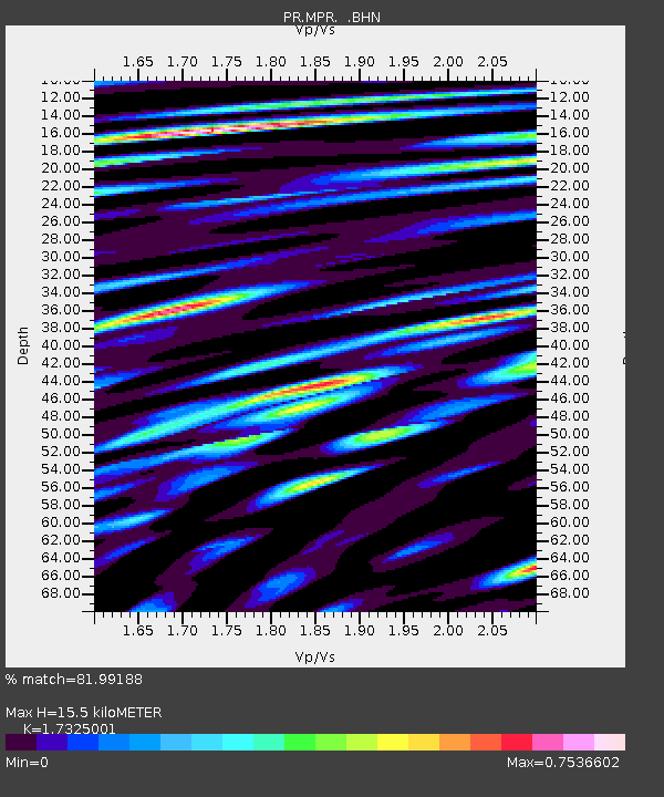
| Estimated Moho Depth: |
15.5 km |
| Estimated Crust Vp/Vs: |
1.73 |
| Assumed Crust Vp: |
5.14 km/s |
| Estimated Crust Vs: |
2.967 km/s |
| Estimated Crust Poisson's Ratio: |
0.25 |
|
| Radial Match: |
81.99188 % |
| Radial Bump: |
400 |
| Transverse Match: |
59.201424 % |
| Transverse Bump: |
400 |
| SOD ConfigId: |
2459 |
| Insert Time: |
2010-03-09 22:33:55.450 +0000 |
| GWidth: |
2.5 |
| Max Bumps: |
400 |
| Tol: |
0.001 |
|

Signal To Noise
| Channel | StoN | STA | LTA |
| PR:MPR: :BHN:20050321T12:30:33.39899Z | 12.387556 | 4.7411886E-6 | 3.82738E-7 |
| PR:MPR: :BHE:20050321T12:30:33.40601Z | 5.987652 | 2.5913048E-6 | 4.3277478E-7 |
| PR:MPR: :BHZ:20050321T12:30:33.405002Z | 28.3781 | 1.31380075E-5 | 4.629629E-7 |
| Arrivals |
| Ps | 2.3 SECOND |
| PpPs | 7.9 SECOND |
| PsPs/PpSs | 10 SECOND |


