You are here: Home > Network List > PR - Puerto Rico Seismic Network (PRSN) & Puerto Rico Strong Motion Program (PRSMP) Stations List
> Station MPR Mayaguez, Puerto Rico > Earthquake Result Viewer
MPR Mayaguez, Puerto Rico - Earthquake Result Viewer
| Earthquake location: |
Near Coast Of Peru |
| Earthquake latitude/longitude: |
-14.3/-76.1 |
| Earthquake time(UTC): |
2007/08/16 (228) 05:16:56 GMT |
| Earthquake Depth: |
23 km |
| Earthquake Magnitude: |
5.8 MB, 6.1 MS, 6.3 MW, 6.2 ML |
| Earthquake Catalog/Contributor: |
WHDF/NEIC |
|
| Network: |
PR Puerto Rico Seismic Network (PRSN) & Puerto Rico Strong Motion Program (PRSMP) |
| Station: |
MPR Mayaguez, Puerto Rico |
| Lat/Lon: |
18.21 N/67.14 W |
| Elevation: |
22 m |
|
| Distance: |
33.5 deg |
| Az: |
15.614 deg |
| Baz: |
195.934 deg |
| Ray Param: |
0.0781578 |
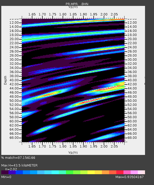
| Estimated Moho Depth: |
43.5 km |
| Estimated Crust Vp/Vs: |
2.02 |
| Assumed Crust Vp: |
5.14 km/s |
| Estimated Crust Vs: |
2.545 km/s |
| Estimated Crust Poisson's Ratio: |
0.34 |
|
| Radial Match: |
87.156166 % |
| Radial Bump: |
400 |
| Transverse Match: |
71.396355 % |
| Transverse Bump: |
400 |
| SOD ConfigId: |
2564 |
| Insert Time: |
2010-03-09 22:33:59.564 +0000 |
| GWidth: |
2.5 |
| Max Bumps: |
400 |
| Tol: |
0.001 |
|

Signal To Noise
| Channel | StoN | STA | LTA |
| PR:MPR: :BHN:20070816T05:23:02.928015Z | 3.4876432 | 1.0651237E-6 | 3.0539925E-7 |
| PR:MPR: :BHE:20070816T05:23:02.940009Z | 3.1056578 | 6.3290304E-7 | 2.0379034E-7 |
| PR:MPR: :BHZ:20070816T05:23:02.909003Z | 11.58584 | 2.7526075E-6 | 2.3758375E-7 |
| Arrivals |
| Ps | 9.0 SECOND |
| PpPs | 25 SECOND |
| PsPs/PpSs | 34 SECOND |


