You are here: Home > Network List > XM99 - Rio Grande Seismic Transect Stations List
> Station NM23 NewMexico23 > Earthquake Result Viewer
NM23 NewMexico23 - Earthquake Result Viewer
| Earthquake location: |
Komandorskiye Ostrova Region |
| Earthquake latitude/longitude: |
55.1/165.4 |
| Earthquake time(UTC): |
1999/11/26 (330) 00:29:00 GMT |
| Earthquake Depth: |
33 km |
| Earthquake Magnitude: |
5.6 MB, 5.8 MS |
| Earthquake Catalog/Contributor: |
WHDF/NEIC |
|
| Network: |
XM Rio Grande Seismic Transect |
| Station: |
NM23 NewMexico23 |
| Lat/Lon: |
33.95 N/106.01 W |
| Elevation: |
1813 m |
|
| Distance: |
62.2 deg |
| Az: |
69.975 deg |
| Baz: |
319.529 deg |
| Ray Param: |
0.060335618 |
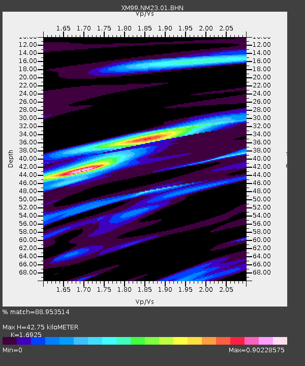
| Estimated Moho Depth: |
42.75 km |
| Estimated Crust Vp/Vs: |
1.69 |
| Assumed Crust Vp: |
6.502 km/s |
| Estimated Crust Vs: |
3.841 km/s |
| Estimated Crust Poisson's Ratio: |
0.23 |
|
| Radial Match: |
88.953514 % |
| Radial Bump: |
400 |
| Transverse Match: |
69.425934 % |
| Transverse Bump: |
400 |
| SOD ConfigId: |
27569 |
| Insert Time: |
2010-02-26 17:34:47.831 +0000 |
| GWidth: |
2.5 |
| Max Bumps: |
400 |
| Tol: |
0.001 |
|
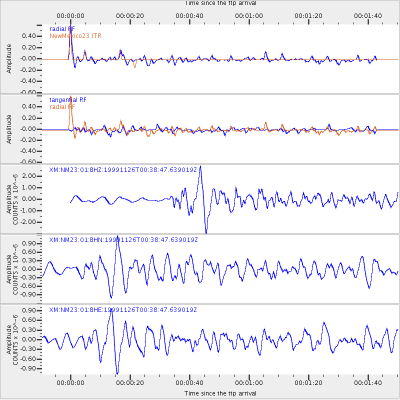
Signal To Noise
| Channel | StoN | STA | LTA |
| XM:NM23:01:BHN:19991126T00:38:47.639019Z | 0.8118743 | 1.4499706E-7 | 1.7859546E-7 |
| XM:NM23:01:BHE:19991126T00:38:47.639019Z | 1.110334 | 1.3080277E-7 | 1.1780489E-7 |
| XM:NM23:01:BHZ:19991126T00:38:47.639019Z | 0.9314458 | 1.7015331E-7 | 1.8267656E-7 |
| Arrivals |
| Ps | 4.8 SECOND |
| PpPs | 17 SECOND |
| PsPs/PpSs | 22 SECOND |


