You are here: Home > Network List > GM - US Geological Survey Networks Stations List
> Station NMP12 New Mexico Permian - Site# W1S2 > Earthquake Result Viewer
NMP12 New Mexico Permian - Site# W1S2 - Earthquake Result Viewer
| Earthquake location: |
Near Coast Of Ecuador |
| Earthquake latitude/longitude: |
-2.1/-79.8 |
| Earthquake time(UTC): |
2022/07/14 (195) 22:30:13 GMT |
| Earthquake Depth: |
81 km |
| Earthquake Magnitude: |
5.7 mww |
| Earthquake Catalog/Contributor: |
NEIC PDE/us |
|
| Network: |
GM US Geological Survey Networks |
| Station: |
NMP12 New Mexico Permian - Site# W1S2 |
| Lat/Lon: |
32.13 N/103.95 W |
| Elevation: |
952 m |
|
| Distance: |
41.0 deg |
| Az: |
328.02 deg |
| Baz: |
141.404 deg |
| Ray Param: |
0.07379963 |
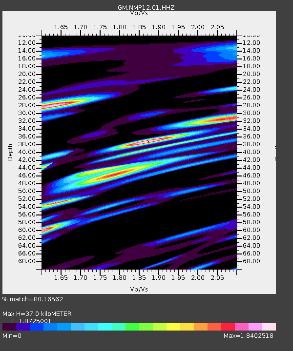
| Estimated Moho Depth: |
37.0 km |
| Estimated Crust Vp/Vs: |
1.87 |
| Assumed Crust Vp: |
6.129 km/s |
| Estimated Crust Vs: |
3.273 km/s |
| Estimated Crust Poisson's Ratio: |
0.30 |
|
| Radial Match: |
80.16562 % |
| Radial Bump: |
400 |
| Transverse Match: |
65.59155 % |
| Transverse Bump: |
400 |
| SOD ConfigId: |
28208852 |
| Insert Time: |
2022-07-28 23:00:27.681 +0000 |
| GWidth: |
2.5 |
| Max Bumps: |
400 |
| Tol: |
0.001 |
|

Signal To Noise
| Channel | StoN | STA | LTA |
| GM:NMP12:01:HHZ:20220714T22:37:17.840007Z | 5.739658 | 1.7149005E-6 | 2.9878095E-7 |
| GM:NMP12:01:HHN:20220714T22:37:17.840007Z | 2.640562 | 5.8444283E-7 | 2.2133275E-7 |
| GM:NMP12:01:HHE:20220714T22:37:17.840007Z | 4.756116 | 9.5289795E-7 | 2.0035215E-7 |
| Arrivals |
| Ps | 5.6 SECOND |
| PpPs | 16 SECOND |
| PsPs/PpSs | 22 SECOND |


