You are here: Home > Network List > PR - Puerto Rico Seismic Network (PRSN) & Puerto Rico Strong Motion Program (PRSMP) Stations List
> Station MTP Vieques, Puerto Rico(T3265) > Earthquake Result Viewer
MTP Vieques, Puerto Rico(T3265) - Earthquake Result Viewer
| Earthquake location: |
Chile-Bolivia Border Region |
| Earthquake latitude/longitude: |
-22.3/-67.9 |
| Earthquake time(UTC): |
2005/11/17 (321) 19:26:56 GMT |
| Earthquake Depth: |
163 km |
| Earthquake Magnitude: |
6.0 MB, 6.9 MW, 6.8 MW |
| Earthquake Catalog/Contributor: |
WHDF/NEIC |
|
| Network: |
PR Puerto Rico Seismic Network (PRSN) & Puerto Rico Strong Motion Program (PRSMP) |
| Station: |
MTP Vieques, Puerto Rico(T3265) |
| Lat/Lon: |
18.10 N/65.55 W |
| Elevation: |
35 m |
|
| Distance: |
40.2 deg |
| Az: |
3.439 deg |
| Baz: |
183.348 deg |
| Ray Param: |
0.07391792 |
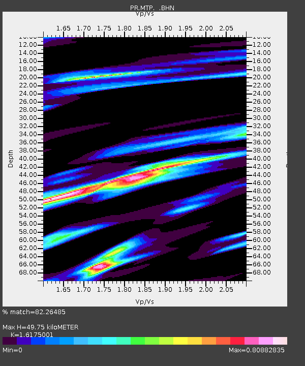
| Estimated Moho Depth: |
49.75 km |
| Estimated Crust Vp/Vs: |
1.62 |
| Assumed Crust Vp: |
5.14 km/s |
| Estimated Crust Vs: |
3.178 km/s |
| Estimated Crust Poisson's Ratio: |
0.19 |
|
| Radial Match: |
82.26485 % |
| Radial Bump: |
400 |
| Transverse Match: |
72.733795 % |
| Transverse Bump: |
400 |
| SOD ConfigId: |
2422 |
| Insert Time: |
2010-03-09 22:34:19.076 +0000 |
| GWidth: |
2.5 |
| Max Bumps: |
400 |
| Tol: |
0.001 |
|

Signal To Noise
| Channel | StoN | STA | LTA |
| PR:MTP: :BHN:20051117T19:33:46.742012Z | 11.011114 | 2.3322393E-6 | 2.1180774E-7 |
| PR:MTP: :BHE:20051117T19:33:46.742012Z | 5.179716 | 1.5892322E-6 | 3.068184E-7 |
| PR:MTP: :BHZ:20051117T19:33:46.742012Z | 20.506802 | 5.044278E-6 | 2.4598074E-7 |
| Arrivals |
| Ps | 6.3 SECOND |
| PpPs | 24 SECOND |
| PsPs/PpSs | 30 SECOND |


