You are here: Home > Network List > PR - Puerto Rico Seismic Network (PRSN) & Puerto Rico Strong Motion Program (PRSMP) Stations List
> Station MTP Vieques, Puerto Rico(T3265) > Earthquake Result Viewer
MTP Vieques, Puerto Rico(T3265) - Earthquake Result Viewer
| Earthquake location: |
Easter Island Region |
| Earthquake latitude/longitude: |
-29.1/-112.3 |
| Earthquake time(UTC): |
2009/09/17 (260) 23:21:38 GMT |
| Earthquake Depth: |
10 km |
| Earthquake Magnitude: |
5.7 MB, 6.0 MS, 6.2 MW, 6.2 MW |
| Earthquake Catalog/Contributor: |
WHDF/NEIC |
|
| Network: |
PR Puerto Rico Seismic Network (PRSN) & Puerto Rico Strong Motion Program (PRSMP) |
| Station: |
MTP Vieques, Puerto Rico(T3265) |
| Lat/Lon: |
18.10 N/65.55 W |
| Elevation: |
35 m |
|
| Distance: |
65.1 deg |
| Az: |
49.754 deg |
| Baz: |
224.588 deg |
| Ray Param: |
0.058487613 |
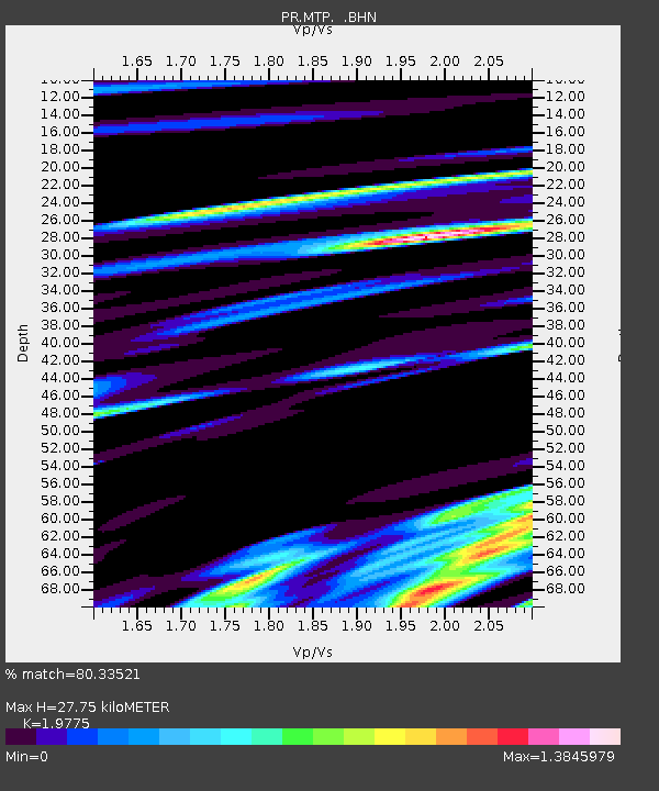
| Estimated Moho Depth: |
27.75 km |
| Estimated Crust Vp/Vs: |
1.98 |
| Assumed Crust Vp: |
5.14 km/s |
| Estimated Crust Vs: |
2.599 km/s |
| Estimated Crust Poisson's Ratio: |
0.33 |
|
| Radial Match: |
80.33521 % |
| Radial Bump: |
400 |
| Transverse Match: |
42.53848 % |
| Transverse Bump: |
400 |
| SOD ConfigId: |
2622 |
| Insert Time: |
2010-03-09 22:34:20.303 +0000 |
| GWidth: |
2.5 |
| Max Bumps: |
400 |
| Tol: |
0.001 |
|

Signal To Noise
| Channel | StoN | STA | LTA |
| PR:MTP: :BHN:20090917T23:31:48.158Z | 3.4890077 | 2.9702187E-7 | 8.513076E-8 |
| PR:MTP: :BHE:20090917T23:31:48.158Z | 1.6035169 | 2.0840704E-7 | 1.2996873E-7 |
| PR:MTP: :BHZ:20090917T23:31:48.158Z | 1.0261337 | 1.7529894E-7 | 1.7083441E-7 |
| Arrivals |
| Ps | 5.4 SECOND |
| PpPs | 16 SECOND |
| PsPs/PpSs | 21 SECOND |


