You are here: Home > Network List > GS - US Geological Survey Networks Stations List
> Station KS28 W Mills Ave, Hutchinson KS > Earthquake Result Viewer
KS28 W Mills Ave, Hutchinson KS - Earthquake Result Viewer
| Earthquake location: |
Near Coast Of Ecuador |
| Earthquake latitude/longitude: |
-2.1/-79.8 |
| Earthquake time(UTC): |
2022/07/14 (195) 22:30:13 GMT |
| Earthquake Depth: |
81 km |
| Earthquake Magnitude: |
5.7 mww |
| Earthquake Catalog/Contributor: |
NEIC PDE/us |
|
| Network: |
GS US Geological Survey Networks |
| Station: |
KS28 W Mills Ave, Hutchinson KS |
| Lat/Lon: |
37.99 N/97.99 W |
| Elevation: |
482 m |
|
| Distance: |
43.3 deg |
| Az: |
338.879 deg |
| Baz: |
152.885 deg |
| Ray Param: |
0.072395064 |
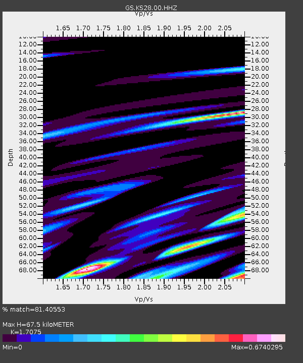
| Estimated Moho Depth: |
67.5 km |
| Estimated Crust Vp/Vs: |
1.71 |
| Assumed Crust Vp: |
6.483 km/s |
| Estimated Crust Vs: |
3.797 km/s |
| Estimated Crust Poisson's Ratio: |
0.24 |
|
| Radial Match: |
81.40553 % |
| Radial Bump: |
400 |
| Transverse Match: |
59.697678 % |
| Transverse Bump: |
400 |
| SOD ConfigId: |
28208852 |
| Insert Time: |
2022-07-28 23:01:33.836 +0000 |
| GWidth: |
2.5 |
| Max Bumps: |
400 |
| Tol: |
0.001 |
|

Signal To Noise
| Channel | StoN | STA | LTA |
| GS:KS28:00:HHZ:20220714T22:37:36.245006Z | 14.95284 | 2.9467276E-6 | 1.9706809E-7 |
| GS:KS28:00:HH1:20220714T22:37:36.245006Z | 5.100807 | 1.4453635E-6 | 2.8335975E-7 |
| GS:KS28:00:HH2:20220714T22:37:36.245006Z | 3.8413017 | 1.0910684E-6 | 2.840361E-7 |
| Arrivals |
| Ps | 7.9 SECOND |
| PpPs | 26 SECOND |
| PsPs/PpSs | 34 SECOND |


